Iceland 2010
From here on out is the story of our first trip to Iceland.
From here on out is the story of our first trip to Iceland.
Posted in Uncategorized | Leave a Comment »
 August 14, 2010
Barely in Iceland and I already anticipate the withdrawal. Just like the post-Olympics letdown leaving Whistler, that I wasn’t expecting, this time I know it’s coming already. I love this place so much already that I’m sure I will be so hungry for it my life will be at least partially focused on how I’m going to get back here.
The reality of going to Iceland and being in Iceland didn’t sink in at all until the airplane. Prior to that I was completely distracted by Kevin’s sudden death and Shambhala and how I was going to get to Calgary, and then how awful Toronto was (abominable! Even without leaving the airport, I felt bitter hate for Toronto. What an awful place.)…that I didn’t feel the reality of going to Iceland until settling into the very back seat of the AirIceland cabin with my brother.  The flight attendants in their distinctive wool hats were murmuring in deep, guttural Icelandic to each other and our chairback TVs played scenic advertising to us- then I got SO excited! Finally struck by the uniqueness of this adventure, and gratitude that it’s possible for us.
We were lucky to have been given the only vacant seat on the plane between us, so we could sprawl a little, and we were both so excited that we didn’t sleep the whole flight, even after next to no sleep the night before (I’d caught what sleep I did on a bench of airport seats). We used our extra seat to full advantage, as it gave us an extra touchscreen “tv”. So I could listen to music on one (a huge selection, like plugging in an ipod, with an all-Icelandic playlist), while watching advertising-laden info-documentaries about all the things to do in Iceland on another,  and then watching flight-progress reports (Are we over Labrador?) on the third. Plus fawning over all the Icelandic on the antimassacars, napkins and flight magazines; cracking the Lonely Planet book for the first time and roughly “planning” our itinerary. So we were so busy and stimulated and thrilled that we didn’t get a wink of sleep on the overnight flight, like owls with ADHD.
Posted in Ísland, Iceland 2010 | Tagged 2010, airplane, arrival, Ísland, flight, from Canada, Iceland 2010, Icelandair, Keflavík | Leave a Comment »

After landing in the rain and early dawn on Keflavik, sleepless, I was starting to get that nauseous all-nighter feeling and dozed woozily the whole bus ride to our hotel. Derek says I missed nothing.
We weren’t expecting to be allowed to check in at 7am, but we were welcomed in (all the Canadians arrive at that time- that’s when the flight from Toronto gets in) and promptly passed out for 4 or 5 hours. It was like getting two nights for one, because we got up and walked all over Reykjavík in the afternoon and then got to sleep at the hotel again.

We were officially welcomed to Iceland by this cat. It’s not every day you both say out loud at the same time “Hey, is that a Norwegian Forest Cat?”
As we walked around Reykjavík I took pictures everywhere of road signs and apartments and houses jutting into the sidewalk, etc, to remember the difference about them, knowing that in no time we’d be so used to it all that we’d stop noticing the uniqueness of common design.
I love the freedom of being a tourist like that. Instead of “Why is that strange woman taking a picture of the roundabout?”, any bizarre behavior gets completely dismissed with “Tourists.” and they barely even look at you, as you’re snapping photos of door handles.![]()

First we headed for the Saga Museum at Perlan, because it was close to our hotel. Little realizing I would practically live on the stuff for the next month, we sampled skyr for the first time at the Perlan cafe on the viewing deck overlooking the city, among a fantastic overload of breakfast sugar. A “Belgian waffle” here bears no resemblance to the grilled pancake batter of NA (North America- I’ll be using this a lot). It’s dark, to start, like whole wheat bread, and thick and “meaty”. Not fluff. You know you’ve eaten something, and it was  delicious. And “cream” in Iceland, whether ice or whipped, is another different animal. It’s not white, and it’s not Cool Whip. It’s cream coloured (wow!) – a distinct yellow buttery colour, and it tastes thick and complete and real. I was in love with the cream in Iceland. It must be local. There are enough cows it would be absurd for the island to import milk. I did not confirm this at all, but kept a fantasy that all the milk there is whole and minimally refined and therefore good for us, because it tasted good.
That was breakfast. Luckily, a delicious introduction to Iceland, because it rather went downhill from that meal, food-wise. I’d later be reduced to wandering gas stations in a hypoglycemic haze going “I just want something that’s not a skink sandwich!” Skinku=ham.
 The Saga Museum is a bunch of wax figures of Vikings being Vikings. Well executed. Static. Except for the animatronic
  breathing Viking. I wasn’t convinced he wasn’t one of those crazy people that stands stone still while people speculate whether or not they’re real, so I spent some time lurking and spying on him from other parts of the museum. Like I was going to jump out from behind the witch being burned at the stake (so that’s where all the trees in Iceland went), all “Aha! You are real! You moved your hand!” No such luck, he just kept breathing and breathing.
The funnest part (and that’s saying something, considering the above-mentioned lurking) was trying on the chainmail and waving around blunt swords which are there for kids to play with. Getting oneself extricated from a 50 pound chainmail dress provides entertainment to all passersby. Can’t believe THAT’s not chained down- that thing is VALuable; an amazing piece of chainmail work. Although, difficult to imagine anyone wearing it out under their clothes to steal. Waving to the person at the desk “Thanks, great exhibit… clanking? what clanking?” Difficult to breathe in, as a matter of fact. Lifting one’s chest against all that metal to inhale is work. Them Vikings were tough.
On to Hallgrímskirkja.

Kirkja=Church. Don’t dare say that like Kirk, a man’s name. It sounds like there’s a bunch of “e”s in it. Hallgrímskirkja is the highest point in Reykjavik, apparently suffered controversy over the design (surprising; considering church design throughout the country, this one looks just like a church) and some bad contractors, and the architect died before it was finished.
 We were quite fortunate; after coming down out of the bell tower, the organist playing in tomorrow nights’ concert was practicing his program on the huge and very unique organ. For free, we got to see and hear the organ boom and rumble. Very exciting, although I would guess not so fun for the organist, to practice with an audience of tourists and cameras milling around. No pressure. The pew seats were another instance of cool design (I was already collecting advanced “scandinavian” design features), which could switch to face either the altar or the organ. Genius.

I loved the clean lines of the church, the most minimal church I’ve ever seen. It may be irreverent, but I couldn’t get fish bones out of my head looking at the lines inside this church, which is actually a compliment because fish are very elegantly designed.
Across from the church we wandered through the sculpture garden of Einar Jónsson at dusk, as the Lonely Planet suggested. The gate was not immediately apparent so we jumped the fence to get in. It was nice to see these bronze castings on our first day, because the whole rest of the trip we recognized his works reproduced in parks and parking lots and generally random places. Clearly he’s an artist beloved in Iceland; his work is just shockingly, compellingly weird and striking. So, love at first sight for me. Can’t believe I’ve never encountered his work before. Some of his stuff is so beautiful it makes you feel ill.

Finding the real gate, we continued, trying to find the Volcano Show on time. Even with a map and not being confused at all, let’s just say we got there circuitously. It’s not really on a street, so it’s kind of hard to find. But we saw some more cats and architecture on the way.
The Volcano Show. Well, can’t tell you much about it, because while I’m sure it was terribly interesting, the soundtrack was incredibly soporific and the little theatre was black out dark. All I retained were visions of orange lava boiling and spewing, hypnotic music, and the feeling of struggling against sleep because something important was happening. Heimaey may have been being destroyed by lava. I jolted awake for intermission, learned Derek had also been asleep, compared notes (we didn’t have many), and went back in to sleep through the second half.
The Volcano Show is the work of Villi Knudsen, who is really funny, has been stealing pens from Icelandic banks since 2008, and cannot quite conceal his glee at the prospect of the next big eruption happening imminently, sure to cause unimaginable chaos, destruction, and loss of life and property (I was wake for his commentary; the lights were still on). Hekla and Katla are both due or overdue. Villi is a volcano chasing son of another volcano chaser, between them capturing 50 years and miles of stunning and one-of-a-kind footage of eruptions. Which we slept through.
 Refreshed, we carried on back into town; light still in the sky at 10:20. We shared a great pizza, made for us by an engineering student, walked through the streets that were beginning to party this Friday night and walked back across town and walked some more, especially after taking the bus one stop too far, about a hundred miles past our hotel (but if we hadn’t, we wouldn’t have seen that one really weird sculpture that made us laugh).
My first impressions of Iceland after one day, as noted in my book:
Google gives Icelandic results first! Water hot as f***. I’m going to spend a lot of time in the water here. Lots of cats. NFLD in corrugated steel. Everyone’s blond.Really, a window into my soul. I hadn’t even twigged to the weird sculpture and ice cream habits of the Icelanders yet, although I’d seen a fair bit of both. I continued to be constantly mind-warped into Newfoundland, what with the picturesque fishing villages and fjords and bright-coloured housing. The similarities are really quite innumerable, although it could never quite be mistaken for exactly the same place. Maybe that contributed to why I felt so damn at home there, all the time. 
Want more pictures?
Posted in Ísland, Iceland 2010 | Tagged 2010, arrival, Ísland, Einar Jónsson, Hallgrímskirkja, Iceland 2010, Keflavík, Lonely Planet, Perlan, Reykjavik, saga museum, sculpture, tourist, travel, Villi Knudsen, Volcano Show, whipped cream | Leave a Comment »
On Day Two we prepared our luggage properly, separating actual camping supplies into backpacks, and city supplies into our suitcases. Since I’d packed to leave by essentially hurling things I thought I’d need at my suitcase, this was an important step to take before entering the hiking phase of our trip.

Elf rock
We dropped off our luggage at BSÍ to be stored (in a room choked with the backpacks and suitcases of other travellers) while we spent some more time in Reykjavik for the day. The Free Walking Tour was worth every cent. We learned a number of things on that short walk, from the talkative, bold Icelandic guide who mentioned sex often, told us what he thought of real estate and Icelandic banks, and who had lived nine years in Canada:
The rock in the picture is an elf rock. When machinery breaks or gets stuck when trying to move a rock, they don’t use bigger machinery, they call in a mediator who negotiates with the tenants of the rock for an amicable solution. In this case it was a week to get ready and a new downtown location. I guess hidden people don’t have so much to pack.
 Reykjavik’s city hall houses a wonderful handmade relief map of Iceland. Odd to say, but it really put Iceland in perspective, especially the magnitude of their glaciers. Iceland’s glaciers spit on our “glaciers”. Vatnajökull wouldn’t deign a glance at the Columbia Icefields. Vatnajökull might give PEI a passing nod. Jökull = Glacier. This beautiful piece of work made of 1mm layers of paper took over 16 “man-years” to create- four people over four years. All those complicated little fjörds. I can imagine whoever worked on the Eastfjörds feeling like Slartibartfast from the Hitchhiker’s Guide to the Galaxy– “those fjörds there- I did those.” It is remarkable.
 Inside, Reykjavík’s city hall looks like a place where work gets done, meaning, it’s not pompous at all and doesn’t put on airs. Maybe an air of streamlined efficiency. Outside, it had a striking wall of moss on rock with portholes in it overlooking a square pond.
 We didn’t notice the anchor on a welded chain rising up out of the water. We saw that a week later when we went by and said “Hey! That anchor couldn’t have been sticking out of the water like that when we were here before, we would have noticed!” Are these people fucking with us? The next time we passed city hall, the anchor was sticking out of the water, but at a totally new angle. By that time, we could file it under weird sculpture, which we were quite familiar with, but we still don’t know what’s up with the anchor and why it does what it does.
Reykjavik 871 +/-2 is perhaps the world’s most oddly named museum (names of attractions rarely include tolerance factors, I’ve noticed), but it had an awesome elevator. What’s most extraordinary about this place is that an entire, modern, multi-storey building is built over top of an archeological dig, completely preserving the excavation and housing an interpretive museum around it. There’s even a window through the sidewalk looking down into the entrance “lobby” of this hall built in 871 (+/- 2 years – hence the name). They don’t seem to think this is remarkable, and all the pictures and info about discovering the remains of the Settlement Age hall under the foundation of a few other builds, the exceptional effort of preserving it, and the engineering of building around it, all live in an unassuming little room adjacent to the bathrooms. We wouldn’t have seen it except for admiring the elevator.

The elevator!
The exhibit itself is quite interactive with lots of high tech flashy bits. We were already noticing a trend with Icelandic museums: there isn’t a lot of actual stuff in them. Not stuff that’s old, and real. Every single Viking and Settlement artifact known in Iceland could fit in a short wing of the British Museum, if not a room. It was a staggering comparison- the incredible glut of collected historical artifacts jam-packed into every museum we saw when we were in London, versus the starkly empty exhibitions of Iceland (with one exception, that comes later). So, there’s a lot of interpretation going on.
 Museums started to feel like books, written on walls. Like being inside a book. Walk around instead of turn pages. This made me crazy. “I want to be outside, not be in a book!” So we’d dart around museums taking pictures of all the copious text, in two-four languages, for reading later someplace more boring (like Canada) and run back outside. Or not go in the museum at all, once they started to become suspect entities. But this opinion coalesced much later on after more museums. All that my notebook said this day was: I’ic museums don’t seem to take very long to go through. As opposed to say, the British Museum, where you should make sure someone knows when you went in and how long you can live on the snack bars you brought, in case they need to send in a search party a few days later.
Despite this “lack of old stuff”, Icelanders know their history with a detailed, intimate completeness that’s unrivaled, thanks to the sagas. Caveat to this generalization about Iceland’s museums: we did not take in the National Museum, unfortunately. Possibly there’s a bunch of stuff there. We also missed the Phallological Museum, a members-only  “must-see”.
Most crucial to our travel plans was the information we could glean about puffins. I was on a mission to see puffins, and we knew our timing was cutting it close, arriving in mid August when the puffins are scheduled to depart.

The Olís cat.
No one seemed to really have their ear to the ground on puffin status in Reykjavik, but consensus seemed to be “you will see puffins still, but they are leaving now.” This solidified our plan for the next couple of days- head for Vestmannaeyjar in pursuit of puffins.
We caught a kid on a two wheeled skateboard and some off-duty blue ninjas practicing in the park on our way to retrieve our packs and get on the road. We got camping gas and ice cream on the way out of town at a gas station that had an interested cat. Cat strolled into the gas station through the automatic door and weaved the aisles like it was looking for something. I shared my ice cream.
 We hitchhiked to Selfoss that night, where we camped among an innundation of German travelers at the campsite. First time with the new tents, and all the research paid off: it rained, and none of our stuff got wet. Success.
***** This better not carry on like this – one post per day? I’ll be writing the most comprehensive Iceland travel diary ever- Journey to the Center of Iceland; 20 000 Photos to See (really, really bad pun). Then again…I’ve little else as exciting to write about for awhile.
Posted in Ísland, Iceland 2010 | Tagged 2010, 871 +/- 2, Ísland, blue ninjas, BSÍ, city hall, elf rock, Free Walking Tour, hidden people, hitchhiking, Iceland 2010, Iceland relief map, Reykjavik, Reykjavik 871, Selfoss, Tjörnin, travel, Vatnajökull | Leave a Comment »

The next morning took us to Vestmannaeyjar. Vestmannaeyjar is an island group off the southwest coast, the largest of which is Heimaey, widely known for its populations of migratory birds, and also for erupting with no warning in 1973 and forcing a five month evacuation of all its inhabitants. We were going there for the puffins.
The puffin is a small, entertaining bird that lives its life at sea except for four months every year when massive flocks of them find the most unfriendly forbidding cliffs in the world and then raise their young there in burrows in the ground. Mid August, the last of the nesting puffins are going back into the sea until next summer. I’m not sure anyone knows quite where they go, but they leave, like clockwork. And we’d been told they were going.
I should take responsibility for the whole puffin thing. I was in Newfoundland ten years and never clapped eyes on a puffin; when we visited St. Mary’s Bird Reserve years later the gannets were in season, the puffins were out. So if there was a puffin in Iceland, I was going to see it.
(There was, and I did). Just in case the suspense was getting to be too much.
 The weather was Maritime; when we got deposited at the new, swoop-roofed ferry terminal, I had to walk around on the breakwater because it was blocking the view. Of course it was only blocking the view of a few hundred meters of ocean, but it still felt elemental to walk around on the recently built breakwater in the insistent wind and rain. Vestmannaeyjar used to have a much longer ferry route to reach it, a three hour trip from þorlákshöfn, but lucky for us, a month ago the new, half-hour route went live from Bakki.
More due to boredom and inattention than anything, I did a really stupid thing in the ferry terminal. We had to wait a fair piece for the next boat, and after getting thrilled on the seawall, there was nothing more to do but eavesdrop on the mysterious international football players in the lobby.  Their presence there made no sense. There were men from more than two continents, switching among at least four languages that I could distinguish, and half of them were wearing their kit. Obviously a team, headed to what? Play in the rain on Heimaey?

Derek amused himself with the talking Icelandic robot vending machine. Feed it a Visa card and let it serve you! So what with all the entertainment, when time rolled around to move upstairs to load in, I just walked away from my journal notebook that I’d set down on the seat beside me.
I’d “prepared” for this eventuality on the transAtlantic flight by writing a heart rending appeal to anyone who might find it, should I lose it, to return it to me, and including every scrap of contact info possible.
From past experience, I know that on a big trip like this, the stimulation barrage is completely overwhelming, and I have to furiously empty my brain’s short-term storage onto paper every night to save the day’s points of interest. Either my RAM’s not adequate or I absorb too much to hold – I don’t know, but I have to do this. In two weeks, I just will not remember the way we heard a horse whinny from the back of a horse trailer traveling the other direction at 100kmh. It sounded like a horse traveling supersonically. And I remember that because I write it down, see? Horse whinnied. So, the notebook I store all these little sensation triggers in is indescribably valuable to me, and I’d said so on the inside cover of this one. Of course, I’d only put two days in it so far.
 I seem to have a thing with losing small notebooks filled with really precious stuff, but I always get them back. No big whoop, I thought when I missed it after the boat took off. We’d be going right back through the same place on the way back; I’d pick it up then.
, that was showing some ancient episode of Friends, in English. With English subtitles. (?)") There was a wee bit of a sea on for our crossing. Derek took an insurance Gravol and I don’t get seasick, so we snickered good at ourselves and everyone else lurching tentatively around, tumbling sideways from one handhold to another, more often than not just running into the opposite
There was a wee bit of a sea on for our crossing. Derek took an insurance Gravol and I don’t get seasick, so we snickered good at ourselves and everyone else lurching tentatively around, tumbling sideways from one handhold to another, more often than not just running into the opposite  wall, oh! and then the first wall again, oh!….
There was a contingent of “I will survive”s clinging to posts at the fore of the cabin, staring unblinkingly at the mostly invisible horizon with clenched jaws as the bow heaved up and down. And the soccer team was roaming around in shorts and socks, squawking in many languages at getting tossed around and at the sideways rain outside. My mouth hurt from laughing.
Disgorged onto Heimaey (no idea where the footballers disappeared to), the rain and fog and wind somewhat influenced our unanimous decision to not camp for the night, made very quickly at the door of the first hostel we passed.  Thrilled with that moment of brilliance, we left our gear and ventured out in full rain garb to see Heimaey on foot.
“See” turned out to be far too strong a word. The fog was Maritime too. Half way up Helgafell, logic kicked in and we asked “for what do we climb?” We could barely see where we were going, enough to recognize it as an incline, but if we continued to the top, we’d only know it was the top because there was no higher ground. Were we climbing to have done it, or for the view?
 We “saw” most of Heimaey in the next few hours just like Helgafell- a short ways ahead of us at a time. In this way, we saw some horses, saw some farms as we trespassed through them, saw the landfill, saw more football pitches than make sense for such a small island, all empty (where was that team headed?) and saw a lot of hraun. Hraun = lava.
We pretty much had no idea where we were, and vaguely wandered back into town after getting really, really wet. Wet doesn’t really translate in photos, but rain drives in through zippers and drips off your face down your neck and hair, and leeches up your sleeves inside the jacket from bare hands, and the whole protective shell you’re wearing delivers all the water you get in the way of down to your boots, where it keeps trying until it breaches whatever waterproofing is making an effort there, promptly turns your boots into small swamp replicas and starts climbing your socks, going “that’s right, we’re gonna get your pants too.”

We rainchecked the bird cliffs, since it seemed a little bit dim to go walking around looking for deadly dropoffs in low visibility, and went back to the hostel to “dry out”. We’ll get you later, puffins. “Dry out”- also too strong a phrase. Cranking the radiator to its cautionary max and opening a window to let out the steam only raised the ambient humidity to about equal the outdoors. But we warmed up, and ate dinner, gathered info (no one had seen puffins today; forecast for tomorrow was more of same), and started a load of laundry.
The promise of the same weather tomorrow meant we may as well go out again tonight to hunt the puffins and then leave tomorrow am for bluer skies. So, back into dry first layers and wet outer layers and back into the dusk in a different direction, hunting puffins. A long trudge, featuring more soccer pitches and more weird sculpture.
We found them! We found the puffins! We found all the puffins that were left, I think. About a dozen of them. They were cute, and entertaining, and brightly sleek in spite of the totally grey conditions. I got the impression that the paltry few that were left were just saying their last goodbyes, that they were taking off for their final flights that very night.
Anti-climactic doesn’t quite cover it. After all that trudging around thinking about my boots being from Squornshellous Zeta, by the time we saw the damn puffins, it was like Thank God, now we can go fall into bed. Puffins, check. Now can I be dry?
We snuck up on them very carefully and… these were the best pictures we got.


Posted in Ísland, Iceland 2010 | Tagged 2010, Ísland, bird cliffs, Heimaey, Helgafell, Iceland 2010, puffins, rain, Vestmannaeyjar, writing | 4 Comments »

Because it was a “sure thing” that the torrential downpour and fog blanket would continue the next day, naturally I opened my eyes at 6am, startled that the sun was beating down on me through the window. I leaped out of bed and into my damp shoes. Completely blue, clear sky. I thought I was gonna bomb around solo, but Derek woke up too while I was getting dressed and came along.
 We could see where we’d been the day before! Without the visibility, the magnitude of the eruption that flowed over part of the town could not be understood. In the crisp dawn air, we climbed up on the hraun, and could see the line where the lava had claimed the ends of streets, where it had destroyed the water tanks, where it had built itself into a mountain and endangered the bay.

We were determined to get on the morning’s departing ferry, so we hurried (in fact, we hurried a little too much, and we lost each other for a time in the maze of hraun when Derek paused to photograph a cat and I ran too far ahead trying to see things fast). We crossed town and climbed a short steep hike for spectacular 360 views of Heimaey’s neighbouring inhabited islands, the volcanic cones and the hraun field of devastation, the colourful, cheerful town, wharf, and Iceland mainland across the water.
“The book” had warned that this hike got treacherous, as it wound around the cliffs where men hunt puffins by hanging from long ropes, swinging to and from the cliffs and snatching the birds off the rock. Traditional method: no harness, just a rope with knots in it. By all accounts madly dangerous, but still practiced on Heimaey.
 We only went to where we could look over the edge of the cliff straight down on cream specks that were sheep grazing the edge of the golf course, took some pictures, basked in the sun, and then scampered back down to our hostel to eat and pack up, starving now from a few hours of moving at a clip and climbing.
We were escorted a few blocks to the Bakari by a large kitten (or small cat?) that was sweetly friendly. Bakari = bakery/cafe (although we saw a whole lot of bakari’s this trip, Heimaey’s was notably superlative). We’d already decided that cats formed a very strong presence in Iceland, and that observation was reaffirmed almost daily.

The ferry ride back across was a completely different animal. Smooth, picturesque; cute blunt-faced gulls later identified as guillemots wheeled around n the surf. When we docked, we more or less ran across the parking lot, determined to catch the ferry traffic as it drove off the boat. If all the cars got away without us in one of them, it was going to be a very long wait or a very long walk down the 30 some km ferry road.
I wasn’t used to Iceland hitchhiking yet.
The moment we reached the road and I spun around and threw out my hand, the next car, with two pretty women in it, stopped for us.
At this point we hadn’t really decided on our next destination. There were two choices- north towards Reykjavik, and south towards Vik. Vik=bay. Influenced by the fact our Finnish drivers were headed north, we decided to go to Hella with them, hitch from there to Landmannalaugar and embark on the four day Landmannalaugar to þórsmörk hike.
 That’s about when I realized I’d completely forgotten the most important mission of yesterday- recovering my precious yellow notebook at the ferry terminal!! Alas. The day was not starting well.
Hovering around Hella, scrounging for something to eat, reading the Lonely Planet’s warnings about this hike and contemplating buying four days of provisions at a gas station brought us around to the conclusion that Landmannalaugar was too ambitious for this day. Instead, we backtracked south again, aiming for Keldur.
Deposited at the turnoff to Keldur, 15 km away, we waited. There was a nice interpretive sign describing the historical site from Njal’s saga perfect for leaning our packs against. Other than the signs, there was nothing. Flat horseless fields, chilling, persistent winds, a grey overcast threatening to rain, and a long flat gravel road. Most pertinently, no cars. After zero cars took this turnoff for a half hour, we discussed walking, perhaps only to the stables four km away, whose roofs we could see. After 45 carless minutes, we debated other plans.

The day was not getting better. My hitchhiking experience tells me that anytime you have to wait a long time, someone special is coming to pick you up, or else there is something developing that you must be delayed in order to encounter. This idea was really tough to relax into though, after just arriving on a terribly exciting island with so much to do. Especially when cold and still damp, waiting for Godot at a drab intersection notable only for how unusually unscenic it was. It was already afternoon, and we hadn’t made it to a single “sight” yet.
Then, a speck appeared in the distance on our gravel road. After more minutes, the speck resolved into a walking person, which eventually became a blond girl walking in yoga pants. She was about to pass us without speaking, as though hitchhikers on a road that no one else seemed to want to travel was an everyday occurrence. When I spoke to her, she pulled out an earbud, told us she walked to the stables daily to unwind after work, and responded to my question about traffic frequency with a shrug. “Every few hours. There’s not much down there,” she said.
That did it. We relinquished Keldur and moved back to the ring road headed south.
Another law of hitchhiking: as soon as you give up on something…. the very next car by turned down the road to Keldur. Arrrugh!!!! Just after that, though, we got a ride from a Spanish couple who were very nice but we could hardly communicate with. They got out and repacked their small 4×4 to fit us in, and as he drove, she wrestled with a huge detailed road map that we envied very much. In fact, we never ever found one like it for sale, and we really could have used one like it many times. They were clearly hunting for something we couldn’t help them at all with, and they only took us a short ways, but we quickly got another ride from a Torf (“turf”) farm worker and fisherman who was very knowledgeable and helpful. He was going way past the Westmannæyar turnoff, so I let go of returning to the ferry to get my notebook. Instead, the young Icelander drove us right into a different weather system and brought us to Seljalandsfoss.
 Seljalandsfoss is a glorious waterfall visible from the highway and visited by hundreds daily. Its loveliest characteristic is that the water freefalls into a pool carved out of the rock that has abundant room behind it to walk right around under and a behind the roaring foss (falls). No cramped, crouching path, either, a thoroughfare with plenty of headroom. The day was looking up! The sun was shining now, and Seljalandsfoss was at the head of the road to þórsmörk. Our new mission was to head for þórsmörk and do the much shorter hike to Skógar.
We trotted further down the road after absorbing the main attraction and hunted out the lesser-seen foss, Gljúfurárfoss, in the back of a lush field behind the very well-appointed camping site Hamragarðar. This foss had carved a canyon out as it retreated into the shelf of rock it fell from, so that now, you can only see the water falling by taking your shoes off and walking in the stream through the narrow gap the water has eroded over millennia. Or you can climb the goat path, using the ropes and ladders provided, and even scramble the last wall of rock, knobby as a climbing gym wall, to look straight down into the shaft that the strand of water currently drops into. Breathtaking! The mist prisms the sunlight into a thousand tiny sparks and the sound of the water striking the bottom many metres below spirals up at you in a roar.
 Thrilled with today’s discoveries, we peacefully got on the road to þórsmörk. The sun was warm enough to get down to a t-shirt. There were some sheep who came and looked at us. There was a bridge over the stream to practice balance walking on. We could watch the tour buses in the distance arriving at and leaving Seljalandsfoss at exact intervals, and there were other entertainments. We could see the mouth of the Gljúfurárfoss canyon, and sound carried well enough for us to get the gist of what the four young men approaching the stream were planning. Especially when three of them started stripping off their clothes. They were speaking another language, my guess Italian, but the top-of-the-lungs bellowing that started as they disappeared over the bank was unmistakable swearing, with unmistakable cause. That water was glacial. We weren’t too far away, either, to hear the sustained laughter of the fourth guy, who opted to climb the goat path instead. The laughter (his and ours), continued as three semi-naked, shrieking and swearing men raced to their car, snatching up shoes and clothes on the run and practically hurling themselves in.
We waited. We made pita bread sandwiches and waited. The afternoon was getting late, but the difference here was that there was traffic. Pretty regularly, a vehicle every ten or fifteen minutes. Most of them were very impressive Hummer-ish trucks with huge tires, roof racks and exterior mounted lock boxes. Straight out of Indiana Jones style. This did not, however, alarm us one bit.
 And then, a Suzuki nearly screeched to a halt by us. It was the Spanish couple! We were old friends now, and they’d already made room for us in their little truck. We were going to þórsmörk. “Yes, yes, þórsmörk.” In moments we bounced off the paved road onto gravel, barely slowing to ignore the sign that admonished only 4×4 vehicles should pass this point, and river crossings were inevitable. This guy drove like an Australian in a hurry. I can’t say I’ve ever been in a car with an Australian, but I imagine an outback driver jouncing around with the contents of the truck smashing from one side to another, all the while talking a streak like XXXXXXX. We were nicely wedged in with our packs on our laps, but still, this drive was impressive. Derek and I grinned at each other, and I was thrilled with this ride totally outside of my realm of hitchhiking experience.
 The road faded into more of a suggestion, as it was all chunky riverbed gravel. The truck bounced up and down and plunged again and again down the banks of small rivers and up the other side. His wife was totally serene, and the two of them looked over their shoulders over and over to piece together chat. We learned he was a professional photographer. They were questing for a glacier, and they’d been trying to reach it all afternoon.
The river crossings grew wider and deeper. Unfazed, our driver drove fearlessly into each one, making water spew up over the windshield and come up the doors. He turned to tell us “rental car”. The surroundings got more and more desolate. Occasionally we stopped and our driver got a camera out of the back with a lens the size of a bazooka to take a couple shots.
We could see civilizationö houses flecks at a great distance to the left. It became apparent that we were driving through a vast river delta, several km wide, and the track we were following meandered across all the streams headed for the sea from the distant glaciers.
 As we started to feel dwarfed by the landscape and more and more in the middle of nowhere, I was increasingly pleased with our fantastic luck to be in this great ride with an intrepid driver in a perfect little 4×4, making this startling journey into the unknown. Nevertheless, here in the unknown, there were still sheep, chewing their cuds and gazing at us like we were crazy.
About 10km into this adventure, the road forked at a sign, and our hosts stopped to confer. We were near Gigjökull, a finger of Eyjafjallajökull. After map consultation and conferencing, the man turned to us, pointed to the right fork, said “we go,” and “you stay here.”
With startled consternation, my brother and I looked at each other. I went through the motions of thanking them profusely with a forced smile as I clambered out with my pack, inwardly gripped with worry. I’d be damned to have come so far and retreat now, but we were officially in the middle of nowhere, halfway between there and back, and our hosts were unflappably abandoning us. Suddenly they seemed like cruel, heartless people. They knew all along they weren’t going to þórsmörk, and yet, they had driven us into the void. In retrospect, the language barrier was too great to distinguish “to þórsmörk” from “towards þórsmörk”. So there we were.
They rumbled off, and there we were, standing next to a fast-flowing translucent river grey with silt. Tire marks drove out of the water on the opposite bank, headed to þórsmörk. After some exclaiming about this unexpected turn of events, I changed to my sandals and strode into the river (Note: river-fording instructions always command that you wear your hikers to protect your feet and ankles. Foolish though it may be, I was determined that the comfort of dry boots, so recently recovered, was too important to sacrifice, and I’d sooner go barefoot into the water. But one should wear boots when crossing rivers. What I say, not what I do). Two steps in and I realized the water was deadly cold. A third of the way across I realized how dangerous it would be to fall. The water was moving so fast and strong when you lifted your foot you had to hard fight the water pulling it away, and at the bottom the water was flipping over big stones that could roll on your feet. Half way across it got quite scary, rolling over my knees. With relief, I made it, dropped my pack and immediately headed straight back across before my feet could get going with screaming at me. I figured I’d help my brother, as a four legged beast would fare better than two, and I didn’t plan on standing by and watching him flounder if he fell, despite his shocked protestations that I was coming back across. He was also carrying the ultra-valuable camera. This time, I fell halfway. I went to all fours, the water dragging at my arms and feet like a wild animal, but I crab-walked a little, recovered, and made it to Derek’s shore. We rested, made a game plan, and then started to ford together holding onto each other. Again halfway, Derek got in a bit of trouble, and although I could barely stand myself, feeling nothing below my knees, I kinda helped him balance his pack and he got back to his feet and crossed. It was absurd luck I made it the first time.

Phew. We looked back at the innocently smooth flowing water, 30 feet width of quietly stealthy danger. Only an unknown further number of fords between us and þórsmörk!
Now we were definitely committed to our goal. We could see it, in fact, a small red roof where the mountains rose up again from the edge of this great rock and sand delta, I reckoned 6km away. We were very lucky. Both of us had legs and arms both soaked, but happily, our packs were bone dry, and our torsos mostly so, so we kept some core heat. We changed quickly, put on toques, and draped all our wet gear over our packs to hopefully dry out a little in the sun as we walked barefoot along the road as the sun dipped towards the earth behind us, laughing at the pure absurdity of all this.

After we’d gone a kilometer or so through the hugest empty space I’ve ever felt, holding only us, silence, and the background purring of water on the move, a vehicle came along behind us. We watched it approach with delight, and I prepared a self-deprecating grin on my face to counteract our drowned-rat appearance, totally confident in the common humanity that makes people help each other in distress, totally confident that this jacked up truck would stop to help us.
It roared right by, barely swerving to avoid us.
We kept walking, slapping along like Gollum, still dripping, but with feeling returning. This time, as we had miles of visibility, we could watch the unhelpful truck bounce along, revealing the route, and judging by his speed, gauge how far we were from that red roof. It was still, optimistically, 6km away. We would not make it by dark.
The next vehicle stopped. It was kind of awing that even out here, there were still trucks coming. This one was a very nice Pathfinder with EU plates driven by an Italian tourist who clearly did not want to take us on board. I understood, as we were going to leak all over his leather interior, but we really needed a ride. He pointed at the hut we were headed for and said “2km, walk”. I said “No, 6km,” and climbed in. I started chatting and charming for all I was worth to make up for imposing ourselves on him, and he warmed up. We encountered more rivers, and they were still getting bigger and deeper. This man was cautious, but determined, and we kept on crossing the fords as I praised and exclaimed and offered encouragement. It really looked like we were going to make it.
Then it got gnarly.
The red roof we’d seen, over 6km away as it turned out, was Húsadalur, still 3km shy of þórsmörk, and the river between us and it wasn’t conceivable to cross. It was thundering, dark, and deep. Húsadalur was totally cut off. Past Húsadalur, the rivers became more frequent, and the river rocks were getting much bigger. This made for a rougher ride, and scarier climbs out of each crossing as the tires strove to purchase on the grapefruit sized and up, round rocks. Worst of all, the track disappeared. Each crossing was only indicated by tire tracks leaving the water on the other side, telling that at least one other driver had made it, and was often hidden when the route is actually driving up the middle of the river to a place where you can get out. Now the rocks were hiding the tracks, so the route became guesswork. Several times he stopped, and we walked in three directions, looking like trackers for tire marks in a patch of sand that revealed the next stage, sometimes backtracking to find the ford.
When we got close enough to see þórsmörk, we started looking for the ford across the main river, peering at our Lonely Planets in our respective languages, and seeking the pedestrian footbridge mentioned therein. There was some long wooden structure on the opposite bank, but it was clearly not a bridge, and the river was formidable and 100 feet wide. I’d have sooner walked into Niagara. We could SEE the þórsmörk hut and its promised hot pools on the other side, but it was utterly unachievable.
An enthusiastically adventure-tour branded Hummer came along, shouted unhelpfully and incomprehensibly at us, and another arriving tour guide, with much angry gesticulation, managed to communicate that he was going back because it was hopeless. Our Italian wasn’t going back. We stopped at the clear end of the road, where the last tracks disappeared into the water at a hopefully wide (and therefore the shallowest) place. Here the mountains were starting again, a craggy field of badlands rising up from the edge of the river. We unpiled from his truck and peered together at the hut across the expanse of water. There were cars on the other side! Cars! How did they get there? I could see the Italian thinking “if they got there, I can”, but it wasn’t possible. I ventured into the nearest marshy shallows of the river far enough to know for sure it was undriveable, and even if we could make it through waist deep parts, we’d never survive that exposure. It was half a km wide of water.

He decided to wait for someone else to come. Why, I wasn’t sure. We’d definitely bonded by now, but still, we were ticks hitching on his mission. I felt like we’d worn out our welcome, and we should shove off and make our own way now. The sun was setting now, the temperature was dropping, and if we were going to camp in this wasteland, we needed to find a place and set up with some light. Derek and I agreed to do this, and I explained our plan to our driver. He looked at us with some alarm, asking where we were going repeatedly. I would gesture sweepingly at the mountain beside us with a big smile and he would frown. He was clearly unconvinced this was an attractive option, but he was also ok to be rid of us, and accepted it. He’d be ok, perhaps he’d sleep in his truck; but first he’d wait for another vehicle.
After goodbye, we plunged headlong into the brush and started clambering up the hill, slowed by the deep sandy volcanic ash and dense brush, aiming to make it over the shoulder of this small mountain and find someplace sheltered and flat to camp. Near the top, another entertainment began below us, and we stopped to rest and watch.  A giant yellow tour bus was approaching. It was clearly adapted for the drive, with impressive clearance and tires. It stopped below us, and the entire contents spilled out, too far away to hear but clear enough to see, taking pictures, smoking, and scurrying into the bushes. The driver conferred with our driver friend for some time. Then the bus swallowed everyone back up, and started to roll. I started to film, sure I was going to have a YouTube hit in the next 5 minutes. The bus went straight into the water, driving smoothly …. and disappeared around the corner of the hill/mountain we’d almost crested. What? We didn’t expect to lose sight of it. We “ran” to the top, reached it out of breath, looked over, and there was no bus. It had utterly disappeared.
Our view, though, was straight into Goðaland, the land of the Gods. Countless towering rock forms like badlands making faces and bodies and creatures of every kind in their caves and complex shapes. It was amazingly beautiful, but the light was so poor now that we did not get very good photos of the complicated texture of the forms, and we never returned to this place.
 We descended the other side of our “mountain” and discovered the most shocking, unexpected thing at the bottom. Emerging from the river where it curved around the mountain we’d just climbed over, was a road. A real road. Clear, pronounced, indisputable: a road. We followed it in, surprised, hopeful, amazed, and happy, under a sunset sky and surrounded by the frozen forms of magic. It was a km or two on this straight road to the mountain hut of Básar. We walked into a shockingly modern and well-equipped encampment we’d no idea was there. Boardwalks, BBQs, showers, numerous timberframe buildings, kitchens, and water taps at the campsites. This was especially startling after the day we’d just had, to find this small city where everyone had 4x4s emerging from the mountains and trees.
There was the disappearing bus. There were a dozen jacked up Toyotas and Pajeros, transporting dozens of tour groups. All of them had driven into the river, followed it around the foot of the mountain, and carried on down the road. 
We tracked down the warden, paid for our camping, quickly climbed a short trail to a marked summit to have a look around, and set up our tents in a lovely magical dell next to a trickle of bubbly creek.
As it turned out, tour vehicles never pick up non-paying riders; the Italian had been the last passenger vehicle of the day and therefore our last chance at a ride. We weren’t being wimps about the river. It’s almost never this high, but the Króssa was flooded because of the sun on the glacier and the heat of the eruption beneath it we didn’t know about yet. When I talked to the hut guide later (when he picked me up hitchhiking), he shook his head in amazement that we made it that day, and said many tours had turned back, because it was so dangerous in flood. The river had tossed the pedestrian bridge aside and downstream, but the next day the water had much subsided, and the bridge was hauled back into place. It also emerged later that Landmannalaugar was a totally unreasonable goal for one afternoon, and to say the road to Keldur was infrequently traveled is a great understatement. So all in all, we couldn’t have done better for this day.

Posted in Ísland, Iceland 2010 | Tagged 2010, þórsmörk, bakari, Básar, Gigjökull, Gljúfurárfoss, Goðaland, Hamragarðar, Húsadalur, Heimaey, hitchhiking, Iceland 2010, Keldur, Krossa, Lonely Planet, river ford, Seljalandsfoss, wet camera | Leave a Comment »
I woke in the morning from a dream that I was in a hot tent. Of course, because I WAS in a hot tent. We’d agreed to sleep to our limit, after such a long and event filled previous day, but by nine or ten o-clock, the sun had made my tent hot enough to melt butter, and I lurched out of it (extricating oneself from a tent made to roll up as compact as a svelte weasel is never graceful) to a glorious blue skied day. By the time I attempted a shower (spent 3kr and still got water that was obviously melted off a glacier that morning), and made some breakfast (opened a can or two), the sun had hit Derek’s tent and he was up.

We packed and started out on our hike, buoyed by the blue sky, light warm breeze, and blissful ignorance of what lay ahead. In fact, our expectations of the day’s hike was entirely based on one paragraph in the Planet, which I will now quote:
The hike starts about 1.5km east of the Básar hut at Goðaland, and then climbs steadily to Mornisheiði, which has dramatic views over Myrdalsjökull, and Eyjafjallajökull. From here, you face a steep ascent to the ridge and Heljarkambur. The next stage takes you across tundra and snowfields to Fimmvörðuháls Pass itself, with Myrdalsjökull on the left and Eyjafjallajökull on the right. The Fimmvörðuháls mountain hut is a short walk off the main track, near a small lake. I used the map gauge to determine this leg of the trip was about 5-6km- a Sunday stroll.
Here’s what it’s really like.

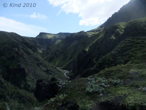
By fortunate luck, Básar was on the same side of the Krossa river as Skógar, our destination. The first 1.5km, no problem. The trail sprouting off of the stony river floodbed was clearly marked, and from there, we started climbing steadily, until in twenty minutes we were looking down on where we’d spent the night from a surprising altitude. Another thirty minutes and the views were truly staggering. We were very much blessed to have a clear day, and we could see glaciers on either side. Every few meters of advance yielded new perspectives on the craggy, columnar rock formations, an almost radioactive brilliance of green moss and foliage in the river valleys on either side, and blackened glaciers on each horizon. We were essentially walking a long ridge, and we did so for a long time.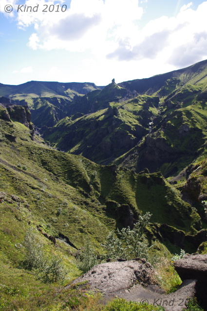
The going was up and down, and here we got our first true taste of the Icelandic fend-for-yourself ethic. This was pretty dangerous stuff. Often, there was a ribbon of pathway at the peak of a very steep sheet of shale that went on for a very long time on both sides. You could preview what would happen to you should you stumble by dislodging a pebble and watching it roll and bounce, accelerating for second after second, after second. The path would wrap around clumps of rock which you’d have to hug and shuffle around. Passing oncoming hikers was something you’d plan for after making eye contact with them, choosing a spot to stop where passing was possible. Only in places of the utmost necessity would there be a few bolts and chains for handholds to grope around a particularly tight place.

At one squeeze, just passing after a troupe of glowing, smiling girls, we came on a grey-haired man leaning into the convex wall of rock that formed the side of the path at that point, gasping and panting, with the look of having seen a ghost in his eyes. I was concerned, and solicitous, and my questions or attention embarrassed him. He made it clear that I should get away from him, and was mortified when he dropped his water bottle, and I picked it up as it rolled away. He gestured insistently that I leave, so I did, but I was worried, especially after what we had just come through. How would this man, hiking alone, navigate all that trail that needed good balance, when he could barely stand at this point?
Not just the views were dizzying, often looking at your feet was. I was pretty comfortable, to be honest, although a good stare down and perspective would get all mixed up, and it would seem that the river valley was rushing up towards you, and it would suddenly seem wise to focus on the path a few hundred feet ahead.

Forgive me for assuming that we had completed the first part, the “then climbs steadily to Mornisheiði”, since we could definitely see two glaciers. That could not have been more wrong. Repeatedly we would crest a mountain/hill that had been dominating our foreground, only to descend for twenty minutes then go up again. As we were obviously following a ridge, we concluded that we must be on to sentence two, until a big mountain face loomed in front of us on the other side of a long mellow descent, with a zigzag traverse climbing to the top. Aha, the “ascent”. We sat in the lush meadow at the base of this to eat lunch. We must have been three hours into the hike at this point, and Derek took some tentative pictures with his camera.

A word about his camera. Two nights earlier, in the Puffin Fiasco, his precious DSLR got wet. In spite of a specialty camera bag the length of an arm, for exactly those conditions, somehow his camera got compromised. Perhaps water ran down the strap, or some other reason, but the screen clearly showed beads of moisture. Since I’d killed a camera before by dunking it, on my advice we took the batteries out, cooked it all night on the room heater, and went out and bought a pound of rice to submerge it in. It looked hopeful for a while, but it just wasn’t behaving right, and it was worrying.
So, all this way, Derek has been packing a camera bag full of rice, packed around his camera in the hopes of pulling the humidity out of it. “That’s one way of carrying food”, he said. Eventually, we did eat that rice.

This “steep ascent to the ridge” felt exactly like the hike above Lake O’Hara, a thigh-burning endless staircase, zigzagging back and forth, ever tighter and steeper towards the top, so tight that you couldn’t really tell how close you were to the top. But from the “summit”, hmmm, this was no ridge. More of the same, really, ups and downs, only the terrain was much rockier, far less green, and remarkably scarier. We weren’t passing people anymore, either. We’d been keeping steady pace with a group of young men that left Básar the same time as us with a guide, but they had left us behind when we stopped to eat. The trail, if it became ambiguous, was marked by a scrap of carved or painted wood weighed down with stones, and those were reassuring.

Another hour or more of a long, rather steady descent (this part, to be honest, is a bit of a blur punctuated by pauses to be shocked at the insane unreality of what we were surrounded by, because it was hard), and we reached an abrupt climb down (imagine a spiral staircase without the stairs) to reach a ribbon of path over two hundred meters long that looked for all the world like the Bridge of Khazad-Dum. That crossed a gap to a wall of mountain on the other side with a bootpack cut into it that could have been the stairs of Cirith Ungol. This was definitely Mordor. We  could see tiny figures summiting the other side that we assumed was the guided group ahead of us. This tiny pathway, the peak of two touching parabolas of grey gravel, was a bridge between two absolutely vast ravines. On the right, the view stretched out to mist over coneshaped mountains and black ice; on the left, a spectacular waterfall hundreds of meters tall was rushing from the leading edge of a glacier funnelled down into a pinch of black sheer cliffs. It raged with such amplitude that even from kilometers away, as we were seeing it, the roar was insistent.
About this time I grasped why the old man had looked like he’d seen the Reaper. He had come down this way! The only thing reassuring about the climb ahead of us was that this HAD to be the “steep ascent.” I think it took an hour. This is the kind of bootpack that you just stop thinking for, focussing all of your attention on lifting your knee again, and making sure, at all costs, that you load your balance forward, so your pack doesn’t pull you backwards. At times, it was as steep as a ladder, so you could use your hands against the hill in front of you for balance, and there were yards of ropes draped along the upper third to haul yourself up. The updrafts of the mountain blew at us, and visibility decreased, not that there was anywhere at all to even pause and turn to look around.

At the start of this climb, the path bridge, we were already at such a dominant altitude that it seemed not right for people to be creeping about any higher in the world. In fact, the top turned out to deposit us on another planet. For a couple miles, we walked across a snowy, smooth and desolate field of rock and ash interrupted only by cairns and footprints. It was amazing. It was essentially the fourth completely different landscape we’d encountered already this day.
 I assumed this was the tundra, but I was ready to throw out the book now because there had been no ridge, and we surrendered to simply hoping that we would encounter the hut eventually. Another significant descent, then ascent, and we crested a hill into yet another colour scheme. Everything here was a rusty red, a light grey, and white. The gravel we were walking now was finer, and chalky, and the path was clear as anything , headed downhill.
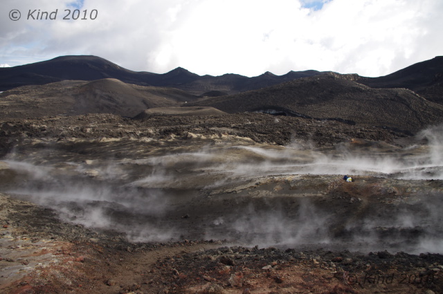
“Check this out!” my brother shouted excitedly. In the middle of the path, a piece of wood the size of my forearm was anchored by rocks in the middle of the trail.  You had to get up close and squint, but it said “new trail”, and pointed right, where indeed, there was an alternative path curving the mountain we were on. Then it all became clear. The old path led straight as an arrow down to where it vanished, obliterated by the half km wide path of lava running perpendicular to us. White, black, rust red, and still steaming, it was obvious. We walked the new trail into a new world, picking our way between puffs of steam by following blue-painted sticks of wood that marked the safe trail across the lava. The ground was warm to touch, but not hot through our boots.

We passed a group who was taking pictures of what happened when they poured water on the ground (for the same experience at home, pour water on a hot woodstove). In the middle of this lava field, Derek’s camera took its last pictures, and expired, turning itself off with an ominous finality.
The sun was getting lower now. It backlit hikers climbing the side of a perfectly cone-shaped volcano with a gorgeous sunset glow-the guided group of four we’d been leapfrogging all day, up on top of this small volcano. Electing to not climb that unmarked trail, we passed them there, and didn’t see them again.

Everywhere we walked, the earth was richly, PEI red, but it wasn’t earth, it was dense, gnarled rock. Amazing, once again. My mind was starting to pop with all the new things I’d seen this day, and it wasn’t over. After navigating the winding path across the hot lava field, we started uphill again, to the right of a bright blue sheet of lake that seemed incongruous in context. As the sun set, mist settled in on us, and we were really pushing now to make that hut. Earlier, I had optimistically thought, we could maybe make it all the way down into Skògar. The book says the hike from Þorsmork to Skògar is “fairly easy”, and “can be done in a long day”, but suggests it is “more enjoyable” to break it up with a night at Fimmvörðuháls. Nine hours of hiking later, in ideal conditions, in excellent health, no injuries, and average weight load; this was definitely more than 6km, we were starving, and there was no way we weren’t spending the night at this hut.
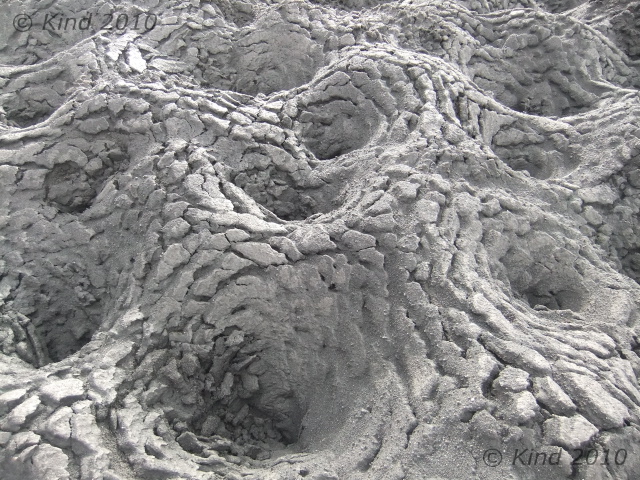
If only we could find it. Our surroundings turned into a monochrome field of the strangest pots, as if the cracked surface of a desert fused with muskeg. My camera, by this time, had gone too long without a fresh battery (two days), and we were turning it on hoping to get one picture on fumes, before it turned off. No time for dallying with settings. As far as one could see – these bowls of ash, various sizes, with the surface everywhere cracked as if from dehydration. Of course, we couldn’t see very far. The mist had swallowed us, blowing away occasionally just long enough to tell we still had no landmarks.
 “There it is,” Derek suddenly said. The fog blew aside and we caught the briefest glimpse of a house shape perched on the edge of an amorphous mountain. Very far away still, a good ways up, and a good ways to the right. The vision floating in the mist reminded me instantly of the Series of Unfortunate Events – the severe house perched on a crag above Lake Lachrymose.
We trudged on, confident now that the hut was indeed still ahead of us. Another hour, or half an hour- time is very hard to judge when you’re tired and hungry- my confidence had evaporated in inverse proportion to the fog, which got denser and thicker. We’d hit the top and had been going down for what seemed for far too long. We almost missed the little sign that said hut, 2km, this way.
Those two km, with about 7m visibility the whole way, were the longest two of the trip. A constant uphill, often muddling around looking for footprints to find the trail, slogging through snowy, muddy ash looking for the Unfortunate Events house, felt like about five km, as the dusk darkened in on us, too. Finally, I stopped in my tracks, howled in despair that we were never going to find it, and just like the movies, a cold blast of wind hit me in the face and whisked away the mist in front of us, revealing the hut looming right on top of us, as close as if we were standing on the lawn in front of it. I had enough time to blink before someone inside gestured to us which entrance we should go to. Derek didn’t stop laughing for about half an hour.

I think we paid $30 each to share one of eight forty-eight inch bunks in this hut, occupied by 19 other people that night, mostly German, and almost all headed the opposite direction. We cooked our dehydrated food packs with melted snow, like everyone else, and we absorbed suggestions from the travellers who’d been here longer. We learned many things that night from the hut keeper, a man who had hiked down to Basar that day to take a shower and pick up supplies and back. We remembered him passing us where we’d had lunch. Speaking several languages always seemingly interspersed, he brushed off his speed as unusual, yes, he knew it so well and did it so often he was like a Sherpa. But even he was impressed at the 7’ tall Belgian guy who made it in after 10pm, having hiked from Altavatn, all in one day. Of course, he ceded, the Belgian’s stride would be almost 2:3 to an average man’s, without exaggeration.

The conical mountain we hadn’t climbed was a new mountain, created by the eruption that had destroyed the old trail. It was a few months old; the lava takes a very long time to cool. This was just a small eruption – a “tourist eruption”, barely newsworthy for Iceland – very accessible though. He laughed, mentioned the sticks painted blue that marked the path across the lava. “One day we thought it was safe, we went out and we made the path- the next day we went back and they were all burnt up- too soon!” he laughed. He laughed at everything. He told us about a french hiker who had set her backpack down to take pictures. “It half burnt up! Half of everything- half sleeping bag, half mat, half backpack!” he laughed. We heard that yesterday’s river had been an anomaly, and that the footbridge we’d seen thrown aside was already reinstalled.
We had covered at least 17km this day. FYI, Planet, very little of it was “fairly easy”. Of all the trail hikes I’ve ever done in Canada, including 19km and 4000′ of elevation in a day, this was worse. The detour around the tourist eruption had added some distance too. The next day, in the light, we would learn we had also taken the longest possible route to the hut, because we couldn’t see the “unmarked” trail.
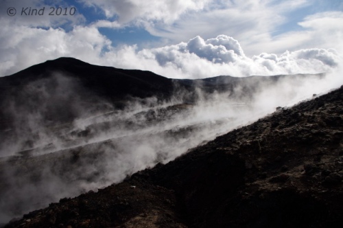
Posted in Ísland, Iceland 2010 | Tagged 2010, Ísland, Básar, Fimmvörðuháls, Goðaland, hiking, Iceland 2010, Iceland hikes, Krossa, Lonely Planet, river crossing, wet camera | 2 Comments »

In the morning the full house erupted rather at once. Notable events of the morning: the hut keeper didn’t recognize me, and was obviously perplexed how I’d gotten into the place during the night without him noticing. The female occupant of the bunk above ours tried to climb up the wall because I was blocking the way to the ladder (the long table down the center of the hut could either be walked around or sat at, not both at the same time- the space was too tight). She was using admirable climbing form, and had her feet above her hands before the sideboard she was grasping gave way and she crashed full onto her back to the floor. I broke her fall a little, and the Belgian snatched a cup of tea out of her path preventing multiple scaldings. She leapt straight up, mostly embarrassed, but it was a hell of a crunch. She thought she’d killed my brother I think, but it was just his backpack.

Rustling around all the other hikers trying at once to stuff bags and get awkwardly out the door, we got ourselves packed and squeezed out, chatting for some minutes on the deck with an Icelander who was thrilled to be escorting two American friends over this hike. The climber girl who had fallen on me, and her boyfriend, in fact. He rhapsodized about fiskar (dried fish) with butter, and proudly shared some orange flavoured Icelandic chocolate, creating instant addicts out of us. The morning was clear and crisp, a “bracing” cold, and the mist was scuttling away so we could see where we had been the night before- an expanse of rolling hills pocked with those mysterious pits. The strange bowls were created by the action of the sun on the layer of ash heating the ice beneath, he explained, and we marvelled at this phenomenon. He pointed out the path we should take down- one of many threads of footprints spidering away from the hut. We could see the tracks of a Cat through the ash that must have brought supplies. He warned us that the first half of the walk down was numbingly boring, and at that we set out into the grey ash desert.
A couple of km down we checked out the “free hut”. It was a corrugated iron shack cabled down to bolts in the ground, with an A-frame outhouse heaped in rocks to keep it from blowing away too. The door opened on an enormous mound of garbage, behind that a filthy plywood floor. The wind was whistling piercingly through the joints, rattling the windows, and banging the door against its latch. Not inviting. We agreed, we were glad we had paid for the Útivist hut.
The Icelander had been right: for a good while the walk down hill was pretty monotonous, following the treads of the Cat, which met a road, which rolled ever onward downhill through this desert of ash. Slowly, the severe landscape changed.  Green was introduced, and on our right, a creek was making itself known in a cleft that got deeper and louder every time we paused and stepped off the road to look down into it. Soon it was a foamy, milky rapids, and later, cleaner, with swirls on the surface that betrayed the speed and depth of the water now. We crossed the river once on a footbridge, and for the rest of the way, the river stayed on our right. Near that bridge we saw our first fox tracks in the ash, and shortly after that it got green. Where there’s green, there’s sheep, so we saw lots of sheep and even more sheep evidence on our way down. The sheep all stared back at us, usually while chewing rythymicly.
Today’s hike was very, very easy. Going downhill generally is. It was a steady, gentle slope. The river beside us, the Skóga, grew larger and fell over a series of falls. Not little waterfalls, either. Considering we were descending a moderate grade, it wasn’t logical how again and again, we’d encounter a huge raging waterfall. An interpretive sign at the end of the road would tell us there were 21 falls on the route we walked this day. There were at least that many. The frequent long stairstep falls probably didn’t count. Unique, gorgeous, calendar beautiful falls, every one! It was an abund ance of beauty that seemed so excessive and extravagant that it became humorous. Derek started saying “Oh, just another foss” at each, next, extraordinary spectacle. “Oh, another foss” was something we said with a grin and shrug quite often the whole rest of our trip, as Iceland turned out to be truly thick on the ground with world class waterfalls. Sometimes we’d hear the roar a ways off; sometimes the sound would be blocked by the land, or we’d turn a corner to discover another, suddenly. Sometimes the trail would wind to the base of a foss, sometimes you would see one below you from the top of a cliff. At every one we were just killing ourselves that we had no camera at all at this point to preserve it with, and we’d just pause and stare instead, trying to fix it in memory. The sound and the mist and the “good ions” made for a very peaceful day’s walk downhill. It was quite far, but not at all hard. The nearer we drew to Skógar, the more oncoming hikers we saw, some out for a day hike up the Skóga, some setting out for Básar.
Most of the time we were walking through trenches in the grass that were sometimes hip deep. The walking trails had compacted down, digging a ditch through the sod. This turned out to be characteristic of trails everywhere in Iceland. When they got too uncomfortably deep, a new trail would start right beside it, so in softer places there would be two or three trenches of varying depths with obvious historical order.

Our hike terminated at Skógafoss, a 62m waterfall missed by few tourists, because it’s readily accessible right off the Ring road at Skógar. We came on it from above, climbing a stile, having a dizzying look down the falls, and at the backs of the gulls circling in the mist and nesting in the mossy rocks. It was like reentering another world; as a tourist attraction, Skógafoss is very well traveled. The steel stairs to the top of the foss are a revolving treadmill of steady foot traffic at all hours. We were grubby, backpacked, and all serene from solitude and exercise. Who were all these people? Society has benefits though- we beelined to the visitor’s centre to immediately plug in our camera batteries and eat, as we had budgeted very accurately for food. In other words, we had none left. Menu options? Minimal. Fries. Chocolate.
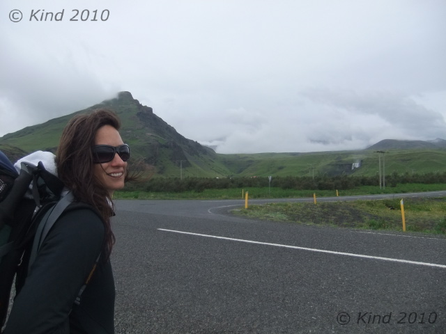
After the recharge, we went back to the waterfall and climbed it again to get some pictures. Then we got on the road and hitched out of Skógar, headed to Vík. Vík is supposed to be a must-see for exceptional basalt columns rising out of the ocean at Reynisdrangur, and the sea arch at Dyrhólaey, and I really wanted to take this in, but we never did. Ironically, we ended up passing through Vík FOUR times, but sadly it remained a list item for “next time”.

This time, it was raining, and we lucked out on a really long ride who was going straight through to Höfn, so we did not stop in Vík, but took the ride to Skaftafell. This super friendly guy who was thrilled to stop anywhere we we curious about to take a picture, and who talked endlessly about the beauty and history of his country as we drove through it, just happened to be former CEO of one of Iceland’s big three banks. Yep, all in a normal day for him to pick up a couple of unwashed Canadian backpackers in the rain. He totally resisted my attempts to draw him out on the topic of Iceland’s recent, crushing economic crash, however.

It was hard to grasp the magnitude of the event from ground level, but this drive crossed miles of sandar -devastation created by the jokülhlaup of the 1362 eruption of the volcano Öræfi. This sandar, Skeiðarársandar, is the largest in the world, a 1000 sq km floodplain of sand deposited by billions of gallons of water released from the glacier by the volcano’s heat beneath it. Even to say you could see it from space is an understatement. A smaller but more recent jokülhlaup event in 1996 took out all the bridges across it like they were made of matchsticks (see picture). When we later saw it from a height, the grey plain is so large that it fades into mist at the horizon, and is totally impossible to take a picture of. It’s just so big, it’s all that you see, for as far as you can see.

At Skaftafell we were greeted by a huge, modern, bustling visitor’s centre, gift shop, and regimented square acres of green lawn for a campsite, which we promptly set our tents up on, in the shadow of a green mound of a mountain. Our tents drew comments, based on their resemblance to alien spacecraft. I didn’t think they were that weird, but I guess, a bit different. Derek did a lot of research before buying our tents, based on weight, ease of setup, and packability. I loved mine. Derek spent an inordinate amount of time fidgeting with his, usually every night, trying to get it perfect. Both of them were ultralight, set up pretty quickly, and dried out very fast, which was perhaps the best feature, since every day we’d wake up in heavy dew if not rain.

Tired from the hike, we got showers (cold), didn’t do laundry (huge lineup), charged all our accessories (“chargers found plugged in here will be confiscated”), and ate in the cafe. The cafe served coffee, sheep soup, cake, skyr, and junk food, all shockingly expensive. I stocked up on skyr, cheese, and chips. My love affair was skyr was just beginning; Derek had already had enough. We watched the looped movie about the ’96 jokülhlaup, repeatedly. I kept falling asleep in it, waking up, and then watching it again to see the parts I’d missed, only to nod off again, until i gave up and went to bed. Well, first: I was craving a hot spring, we were hitting a week here without having been in one, and everyone we talked to was raving about hot spring this and that, so I hitched up the road to a pool noted in the LP that was supposed to be very nice, only to arrive just as they were closing for the night, alas. It was dull, rainy, and we couldn’t see a thing for the heavy fog, but we were content to crash.

Posted in Ísland, Iceland 2010 | Tagged 2010, Ísland, camping, Fimmvörðuháls, hiking, Iceland 2010, Iceland hikes, sandar, sheep, Skaftafell, Skóga, Skógafoss, Skógar, Vík | 1 Comment »

August 19, 2010
There is wild magic here. The dreamworld is very close. Everything raw and numinous lives here, and I feel magic in everything.
The wildness in everything is dangerous and thrilling, and this feeling of being completely alive seems somehow close to death. As I clamber around, I find myself breathing gratitude with every step. Thanks to the seaweed, to every rock I touch, the grass, the rain, the wind, to the spirit or life in it all for supporting my feet and my life, when everything could turn with one trip or a stumble or a moment’s loss of balance. Balance, in fact, feels like it’s always hovering on the edge of a blade in Iceland.
I feel this sense of peace and belonging that I’ve rarely felt. I did in the Yukon as well, but I’m reluctant to say that it’s the almost-Arctic north that does it. Perhaps it’s the space- there’s so much of it, not enough people to fill it with energy and thought-noise. Maybe there’s still room here for the spirit world. Perhaps it’s the youth of the landscape. The earth is literally still creating itself here.
There is so much elemental power and energy flowing around, it’s no surprise that the locals accept the existence of “hidden people” as obvious. I regularly get my hair raised and that “walked over my grave” feeling. Oddly, today I felt as if I’d walked over my own grave.
Posted in Ísland, Iceland 2010 | Tagged 2010, Ísland, hidden people, Iceland 2010, magic, spirit | Leave a Comment »

I was up with the first sunbeam to a gorgeous, cloudless day. I jumped on laundry, although making the electronic washing machine work was a bit of a time-consuming challenge, and several other early risers got involved with me pushing buttons, before the thing miraculously came alive. After that I was a relative expert, and had to start the thing repeatedly for other foreigners. (Hold this button for ten seconds, then press this one and this one at the same time, then release the first while holding this other one, then wait 5 seconds, then press this one). Really. Or at least it seemed like that. It was like arcane knowledge passed down between travellers.
I felt blessed to be able to watch the mist coil away from the grass, lift off the mountains and the glacier, to reveal for the first time where we actually were. I made good use of my Thermarest chair (essential), ate skyr, and made notes in the white space borders of our LP guide, as I was still bereft of my journal. The ground was drenched with dew and very cold on the soles of my feet, as I made frequent barefoot missions to confirm that the laundry STILL wasn’t finished. Eventually I gave up and hung all our socks on the bushes and the guy lines of our tents, in good company with all the other campers. Something is up with their laundry. The first time I spent $16 and three f@#king hours to do one load of laundry I thought it was anomalous. The third time it happened, laundry ceased to be that big a priority.

After leisurely awakening, we decided to spend another night based here, bought new tent tags, then left around 10am for Jokülsárglón, a little further east down the Ring road, getting a ride from a French/Swiss couple with barely enough room for themselves and their gear in the car, let alone us. But hop in!

Jokülsárglón is another site of stunning beauty easily reached off the Ring road that could be considered a tourist trap. They definitely process a great many tourists that come for a quick lap in the amphibious boats, a few pictures, and maybe a waffle.  What it is is a great glacial lagoon formed by the ice melt off a tongue of the (inconceivably huge) Vatnajökull glacier, filled with little icebergs calving off the glacier, then drifting slowly towards the sea. The ocean’s tide backwashes into the lagoon, so it’s partially salt water, and the seals come in for respite too.
 Good tourists, we promptly hopped aboard the next amphibious boat departure, price be damned, which drove into the water and toodled around among the icebergs, preceded by a zodiac there to find a safe route. A beautiful Icelandic girl in a skidoo suit with a river of blond hair told us in perfect English how quickly the glacier was retreating now, 100s of meters faster every year, but that was ok, because global warming wasn’t happening fast enough for Icelanders. She held a big chunk of ancient ice with bare hands as she talked, then passed it around for the photo ops and smashed it up on the deck of the boat into little chunks for us to nibble on. I really liked the amphibious vehicle, and the transition from water to land, as you could feel the engine switch to the axles again and drive out of the water(no one else seemed quite as excited as me so I tried to keep a lid on it).
That was the Jokülsárglón tourist experience. One can also walk leisurely around the banks of the lagoon and take pictures from the land. Other interesting facts are that they filmed parts of Tomb Raider and Die Another Day here, and to do so they artificially froze some of the lake, and closed off the lagoon from the ocean (!).
The icebergs are gorgeous: stacked layers of white and blue and turquoise with streaks of black ash, and different degrees of opacity, depending on how the ice was formed in the glacier and the pressures exerted, on how long they’d been in the lagoon and how recently they’d rolled over, and on the vagaries of the sun’s action upon them. We could have taken 100 times as many pictures here as we did, and Derek’s not having his DSLR hurt.

 From the blue iceberg lagoon (time limited offer- will no longer exist in 25 years or less), we inhaled waffles with jam (breakfast was non-existent at Skaftafell, although sheep soup would be reheated later, ten bucks a bowl), and walked across the bridge and the road to where the lagoon really comes out to meet the sea.
  Glistening, perfectly clear and intricately sculpted pieces of ice like we had sampled on the boat were washed up everywhere on the ash-black sand beach, looking for all the world like a black and white photo even in colour. We spent some time here, taking pictures of the millenium-old ice in their last days as ice before returning to water, handling the smooth rocks and waiting for the other hitchhikers to be picked up before we got back on the road.

 We got a ride back to Skaftafell with an Austrian couple. I don’t remember any of it. I was making a habit by this time of falling asleep as soon as I got in a vehicle or a movie. It was starting to make me worry. So weird, but as soon as I put the seatbelt on, it seemed, I was struggling to stay awake. Still early in a sunlit day, we seized the opportunity to go on a glacier tour. Only the beginner tour (“Intro to glaciers”), as we couldn’t afford much else.
Before that tour departed, we ran over to see the glacier that we were essentially camped beside, a short walk off the visitor’s centre to the oozing spread of ice reaching down towards sea level, and the canyon it had created. The plain before it was rugged, scraped and sandy, with some rugged shrubbery, pools and rivers of cement, and an awesome view up over the cracking, pressured ice near the bottom to the expanse of snow and ice that Vatnajökull is. There’s something about that much ice that can silence you with power. It’s not silent though, it groans. All night, it sounded like far off thunder, the ice heaving in the night.
Vatnajökull is vast.
We have some glaciers in Canada. You can walk around on them and drive on them and even go on a very similar guided tour. See the rocks that are mossy on all sides, see the cauldrons formed by whirlpools. But Vatnajökull is larger than PEI (a bit smaller than Cape Breton), the same size as Lake Titicaca, with ice a kilometer thick. All you can ever see of it at once is one little finger of it reaching between mountain ranges.

Our glacier tour was really lucky, there were only the two of us plus one crazy Isreali (non-stop clowning around), with our quintessentially Icelandic guide (rugged, blonde, stoic), who was also very indulgent, letting us climb down into any of the maligns and crevasses, and climb higher and higher on the glacier, although he was really unhappy when we came down to see a family of tourists clambering around on the ice in running shoes. “I will not rescue you when you fall in”, he spat, disdainful of fools. On the way home the tour bus even paused at a gas station/grocery store, for us to buy bananas (a miracle!), rice (lifesaving!) and tomato sauce (hallelujah!) for dinner, which the Icelander approved of. “College food”, he nodded.
We were starting to notice the food in Iceland, or rather the lack of it. There’s plenty of chocolate and plenty of ice cream, but there never seems to be much choice for veggies and entrees. Between Vík and Höfn (150 miles), there seems to be two places to eat. The visitor’s centre (sheep soup again?) and the Jokülsárglón cafe. Waffles. Delicious, but they’re two mouthfuls apiece; start with three per person. This was a hungry day. A person cannot live on skyr alone! Not at this pace, anyways.
Back at our campsite in the lee of ridiculous vistas, we made rice, and saw the couple who had left us to our own devices at Gigjökull again. Iceland is a really small world, for tourists at any rate. Skaftafell is a major hub. Oh, there’s that other hitchhiker, the one that had the Vík sign (wave); oh, there’s that Austrian couple again, (wave, “Hi!”); oh, there’s the unusually tall Belgian… you see other travellers over and over again at different hikes and campsites, and on the road.
 After wolfing down dinner for four between the two of us, we went for a hike up to Sjónarsker. Buried in the hills above us was Svartifoss, foss of a thousand postcards. It was a long steep walk down to it (after walking very high up), and along the there were several other unique little fosses- long ribbons, wide washes that fell in steps, and there was a mossy structure that seemed to house a now-disused hydro-electric generator. This was one of my favourite fosses of Iceland, although it wasn’t all that swashbuckling, considering the majestic curtains of water we’d already seen. It was just… special. It was like a cave, the bowl of space that held the fall, damp with mist held in the air and dripping off the black rock.
  It’s the black basalt that makes this one so unique, all the columns of hexagonal rock for all the world like a church organ turned to stone. In the river’s spill out, there were piles of boulders, all hexagonal, different lengths, different dimensions, but all black, all six sided, everywhere you looked. Amazing.
 We lingered around that strangely “holy” pool and its quiet trickle of waterfall for awhile, then carried on up and out of the ravine and across the top towards the glacier again. This was a profoundly magical place, something I’d only visited in J.R.R. Tolkien’s imagination. After gaining altitude, we could see over the sandar, the surviving evidence of power on a biblical order, and then we were in a maze of trails and boardwalks through short trees and thick hedgelike bushes. It was exactly like being hobbits. I would lose sight of my brother ahead of me, then would see him bobbing along among the twilit green.
  The sun started to set in the west, silhouetting the peak behind us and setting the whole sky and the smattering of clouds ablaze in colours that would change by the second. In the other direction, the setting sun was lighting up the snowy alpine of the mountains beyond the glacier with pinks and oranges and blues that looked fake. Us, tiny creatures in between, wandered among the shrubs, laid on the moss that felt thick as muskeg, and ate blueberries by the handful, giving up on capturing any of this on camera.

This area is intricate with hiking trails. I really don’t know exactly where we went, or how far, but we climbed for hours. The sun seemed to never set, and we just kept going. Eventually we reached the lip of the glacier-formed canyon of “our” finger of Vatnajökull that terminates at Skaftafell,  so we knew where we were. We were so high here, looking down from the cliff onto the ice, almost small below us, and across the wide canyon at jagged, majestic mountains. I was seized by an urgent and totally illogical urge to summit Kristínartindar, a conical, steep peak with a clear trail up it, although it was nearly dark. It was right there! So close! Derek groaned; we argued. Derek put his foot down and talked me out of it, after I tried to talk him into letting me go alone. At this point, the sun was well below the horizon, but there was still light, a dreamy, glowing kind of light that seemed to come from everywhere.
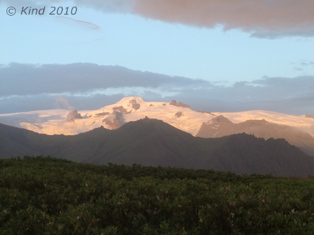
I bargained with myself I’d climb here again in the morning (I did not), and headed down with Derek. About an hour down, and descending started to seem just as hard as the ascent, plus we were in total darkness eventually, with meek headlamps, and it was gnarly. Wet and slippery, rocky, craggy, and thick with strong, stubborn trees. By the time we made it back to camp, my legs were jelly. Sleep hit hard and fast, and the glacier went on thundering through the night.

Posted in Ísland, Iceland 2010 | Tagged 2010, Ísland, camping, food, glacier, glacier tour, glaciers, hiking, icebergs, Iceland 2010, Iceland hikes, Jokülsárglón, Kristínartindar, lagoon, sandar, Skaftafell, Svartifoss, Vatnajökull | Leave a Comment »
Our first visit to Iceland in 2010 demanded another, and we went to Iceland again in 2012, this time with my husband and two bicycles.
This is the site I created to tell the story. Click on my picture for my home blog.
We traveled Iceland for 27 days in 2010, and that is described day by day, in great detail (scroll down to "Iceland 2010", and "Day 1"). The dates have been adjusted so that the tale of the 2010 trip reads chronologically.
Numerous extra photos that didn't fit neatly into each post can be found through the tabs at the top of the page.


