I woke in the morning from a dream that I was in a hot tent. Of course, because I WAS in a hot tent. We’d agreed to sleep to our limit, after such a long and event filled previous day, but by nine or ten o-clock, the sun had made my tent hot enough to melt butter, and I lurched out of it (extricating oneself from a tent made to roll up as compact as a svelte weasel is never graceful) to a glorious blue skied day. By the time I attempted a shower (spent 3kr and still got water that was obviously melted off a glacier that morning), and made some breakfast (opened a can or two), the sun had hit Derek’s tent and he was up.

We packed and started out on our hike, buoyed by the blue sky, light warm breeze, and blissful ignorance of what lay ahead. In fact, our expectations of the day’s hike was entirely based on one paragraph in the Planet, which I will now quote:
The hike starts about 1.5km east of the Básar hut at Goðaland, and then climbs steadily to Mornisheiði, which has dramatic views over Myrdalsjökull, and Eyjafjallajökull. From here, you face a steep ascent to the ridge and Heljarkambur. The next stage takes you across tundra and snowfields to Fimmvörðuháls Pass itself, with Myrdalsjökull on the left and Eyjafjallajökull on the right. The Fimmvörðuháls mountain hut is a short walk off the main track, near a small lake. I used the map gauge to determine this leg of the trip was about 5-6km- a Sunday stroll.
Here’s what it’s really like.

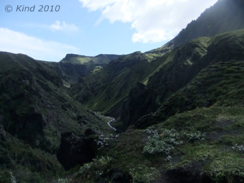
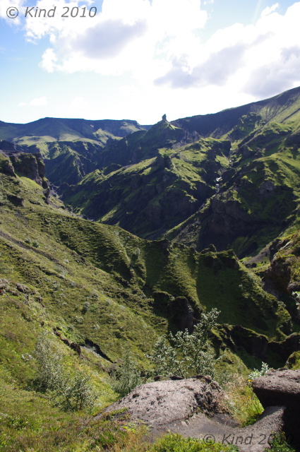
By fortunate luck, Básar was on the same side of the Krossa river as Skógar, our destination. The first 1.5km, no problem. The trail sprouting off of the stony river floodbed was clearly marked, and from there, we started climbing steadily, until in twenty minutes we were looking down on where we’d spent the night from a surprising altitude. Another thirty minutes and the views were truly staggering. We were very much blessed to have a clear day, and we could see glaciers on either side. Every few meters of advance yielded new perspectives on the craggy, columnar rock formations, an almost radioactive brilliance of green moss and foliage in the river valleys on either side, and blackened glaciers on each horizon. We were essentially walking a long ridge, and we did so for a long time.
The going was up and down, and here we got our first true taste of the Icelandic fend-for-yourself ethic. This was pretty dangerous stuff. Often, there was a ribbon of pathway at the peak of a very steep sheet of shale that went on for a very long time on both sides. You could preview what would happen to you should you stumble by dislodging a pebble and watching it roll and bounce, accelerating for second after second, after second. The path would wrap around clumps of rock which you’d have to hug and shuffle around. Passing oncoming hikers was something you’d plan for after making eye contact with them, choosing a spot to stop where passing was possible. Only in places of the utmost necessity would there be a few bolts and chains for handholds to grope around a particularly tight place.

At one squeeze, just passing after a troupe of glowing, smiling girls, we came on a grey-haired man leaning into the convex wall of rock that formed the side of the path at that point, gasping and panting, with the look of having seen a ghost in his eyes. I was concerned, and solicitous, and my questions or attention embarrassed him. He made it clear that I should get away from him, and was mortified when he dropped his water bottle, and I picked it up as it rolled away. He gestured insistently that I leave, so I did, but I was worried, especially after what we had just come through. How would this man, hiking alone, navigate all that trail that needed good balance, when he could barely stand at this point?
Not just the views were dizzying, often looking at your feet was. I was pretty comfortable, to be honest, although a good stare down and perspective would get all mixed up, and it would seem that the river valley was rushing up towards you, and it would suddenly seem wise to focus on the path a few hundred feet ahead.

Forgive me for assuming that we had completed the first part, the “then climbs steadily to Mornisheiði”, since we could definitely see two glaciers. That could not have been more wrong. Repeatedly we would crest a mountain/hill that had been dominating our foreground, only to descend for twenty minutes then go up again. As we were obviously following a ridge, we concluded that we must be on to sentence two, until a big mountain face loomed in front of us on the other side of a long mellow descent, with a zigzag traverse climbing to the top. Aha, the “ascent”. We sat in the lush meadow at the base of this to eat lunch. We must have been three hours into the hike at this point, and Derek took some tentative pictures with his camera.

A word about his camera. Two nights earlier, in the Puffin Fiasco, his precious DSLR got wet. In spite of a specialty camera bag the length of an arm, for exactly those conditions, somehow his camera got compromised. Perhaps water ran down the strap, or some other reason, but the screen clearly showed beads of moisture. Since I’d killed a camera before by dunking it, on my advice we took the batteries out, cooked it all night on the room heater, and went out and bought a pound of rice to submerge it in. It looked hopeful for a while, but it just wasn’t behaving right, and it was worrying.
So, all this way, Derek has been packing a camera bag full of rice, packed around his camera in the hopes of pulling the humidity out of it. “That’s one way of carrying food”, he said. Eventually, we did eat that rice.

This “steep ascent to the ridge” felt exactly like the hike above Lake O’Hara, a thigh-burning endless staircase, zigzagging back and forth, ever tighter and steeper towards the top, so tight that you couldn’t really tell how close you were to the top. But from the “summit”, hmmm, this was no ridge. More of the same, really, ups and downs, only the terrain was much rockier, far less green, and remarkably scarier. We weren’t passing people anymore, either. We’d been keeping steady pace with a group of young men that left Básar the same time as us with a guide, but they had left us behind when we stopped to eat. The trail, if it became ambiguous, was marked by a scrap of carved or painted wood weighed down with stones, and those were reassuring.

Another hour or more of a long, rather steady descent (this part, to be honest, is a bit of a blur punctuated by pauses to be shocked at the insane unreality of what we were surrounded by, because it was hard), and we reached an abrupt climb down (imagine a spiral staircase without the stairs) to reach a ribbon of path over two hundred meters long that looked for all the world like the Bridge of Khazad-Dum. That crossed a gap to a wall of mountain on the other side with a bootpack cut into it that could have been the stairs of Cirith Ungol. This was definitely Mordor. We  could see tiny figures summiting the other side that we assumed was the guided group ahead of us. This tiny pathway, the peak of two touching parabolas of grey gravel, was a bridge between two absolutely vast ravines. On the right, the view stretched out to mist over coneshaped mountains and black ice; on the left, a spectacular waterfall hundreds of meters tall was rushing from the leading edge of a glacier funnelled down into a pinch of black sheer cliffs. It raged with such amplitude that even from kilometers away, as we were seeing it, the roar was insistent.
About this time I grasped why the old man had looked like he’d seen the Reaper. He had come down this way! The only thing reassuring about the climb ahead of us was that this HAD to be the “steep ascent.” I think it took an hour. This is the kind of bootpack that you just stop thinking for, focussing all of your attention on lifting your knee again, and making sure, at all costs, that you load your balance forward, so your pack doesn’t pull you backwards. At times, it was as steep as a ladder, so you could use your hands against the hill in front of you for balance, and there were yards of ropes draped along the upper third to haul yourself up. The updrafts of the mountain blew at us, and visibility decreased, not that there was anywhere at all to even pause and turn to look around.

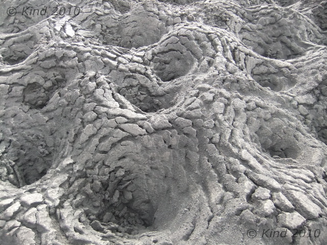
At the start of this climb, the path bridge, we were already at such a dominant altitude that it seemed not right for people to be creeping about any higher in the world. In fact, the top turned out to deposit us on another planet. For a couple miles, we walked across a snowy, smooth and desolate field of rock and ash interrupted only by cairns and footprints. It was amazing. It was essentially the fourth completely different landscape we’d encountered already this day.
 I assumed this was the tundra, but I was ready to throw out the book now because there had been no ridge, and we surrendered to simply hoping that we would encounter the hut eventually. Another significant descent, then ascent, and we crested a hill into yet another colour scheme. Everything here was a rusty red, a light grey, and white. The gravel we were walking now was finer, and chalky, and the path was clear as anything , headed downhill.
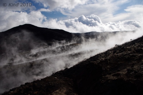
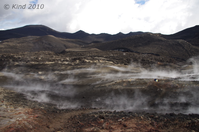
“Check this out!” my brother shouted excitedly. In the middle of the path, a piece of wood the size of my forearm was anchored by rocks in the middle of the trail.  You had to get up close and squint, but it said “new trail”, and pointed right, where indeed, there was an alternative path curving the mountain we were on. Then it all became clear. The old path led straight as an arrow down to where it vanished, obliterated by the half km wide path of lava running perpendicular to us. White, black, rust red, and still steaming, it was obvious. We walked the new trail into a new world, picking our way between puffs of steam by following blue-painted sticks of wood that marked the safe trail across the lava. The ground was warm to touch, but not hot through our boots.

We passed a group who was taking pictures of what happened when they poured water on the ground (for the same experience at home, pour water on a hot woodstove). In the middle of this lava field, Derek’s camera took its last pictures, and expired, turning itself off with an ominous finality.
The sun was getting lower now. It backlit hikers climbing the side of a perfectly cone-shaped volcano with a gorgeous sunset glow-the guided group of four we’d been leapfrogging all day, up on top of this small volcano. Electing to not climb that unmarked trail, we passed them there, and didn’t see them again.

Everywhere we walked, the earth was richly, PEI red, but it wasn’t earth, it was dense, gnarled rock. Amazing, once again. My mind was starting to pop with all the new things I’d seen this day, and it wasn’t over. After navigating the winding path across the hot lava field, we started uphill again, to the right of a bright blue sheet of lake that seemed incongruous in context. As the sun set, mist settled in on us, and we were really pushing now to make that hut. Earlier, I had optimistically thought, we could maybe make it all the way down into Skògar. The book says the hike from Þorsmork to Skògar is “fairly easy”, and “can be done in a long day”, but suggests it is “more enjoyable” to break it up with a night at Fimmvörðuháls. Nine hours of hiking later, in ideal conditions, in excellent health, no injuries, and average weight load; this was definitely more than 6km, we were starving, and there was no way we weren’t spending the night at this hut.

If only we could find it. Our surroundings turned into a monochrome field of the strangest pots, as if the cracked surface of a desert fused with muskeg. My camera, by this time, had gone too long without a fresh battery (two days), and we were turning it on hoping to get one picture on fumes, before it turned off. No time for dallying with settings. As far as one could see – these bowls of ash, various sizes, with the surface everywhere cracked as if from dehydration. Of course, we couldn’t see very far. The mist had swallowed us, blowing away occasionally just long enough to tell we still had no landmarks.
 “There it is,” Derek suddenly said. The fog blew aside and we caught the briefest glimpse of a house shape perched on the edge of an amorphous mountain. Very far away still, a good ways up, and a good ways to the right. The vision floating in the mist reminded me instantly of the Series of Unfortunate Events – the severe house perched on a crag above Lake Lachrymose.
We trudged on, confident now that the hut was indeed still ahead of us. Another hour, or half an hour- time is very hard to judge when you’re tired and hungry- my confidence had evaporated in inverse proportion to the fog, which got denser and thicker. We’d hit the top and had been going down for what seemed for far too long. We almost missed the little sign that said hut, 2km, this way.
Those two km, with about 7m visibility the whole way, were the longest two of the trip. A constant uphill, often muddling around looking for footprints to find the trail, slogging through snowy, muddy ash looking for the Unfortunate Events house, felt like about five km, as the dusk darkened in on us, too. Finally, I stopped in my tracks, howled in despair that we were never going to find it, and just like the movies, a cold blast of wind hit me in the face and whisked away the mist in front of us, revealing the hut looming right on top of us, as close as if we were standing on the lawn in front of it. I had enough time to blink before someone inside gestured to us which entrance we should go to. Derek didn’t stop laughing for about half an hour.

I think we paid $30 each to share one of eight forty-eight inch bunks in this hut, occupied by 19 other people that night, mostly German, and almost all headed the opposite direction. We cooked our dehydrated food packs with melted snow, like everyone else, and we absorbed suggestions from the travellers who’d been here longer. We learned many things that night from the hut keeper, a man who had hiked down to Basar that day to take a shower and pick up supplies and back. We remembered him passing us where we’d had lunch. Speaking several languages always seemingly interspersed, he brushed off his speed as unusual, yes, he knew it so well and did it so often he was like a Sherpa. But even he was impressed at the 7’ tall Belgian guy who made it in after 10pm, having hiked from Altavatn, all in one day. Of course, he ceded, the Belgian’s stride would be almost 2:3 to an average man’s, without exaggeration.

The conical mountain we hadn’t climbed was a new mountain, created by the eruption that had destroyed the old trail. It was a few months old; the lava takes a very long time to cool. This was just a small eruption – a “tourist eruption”, barely newsworthy for Iceland – very accessible though. He laughed, mentioned the sticks painted blue that marked the path across the lava. “One day we thought it was safe, we went out and we made the path- the next day we went back and they were all burnt up- too soon!” he laughed. He laughed at everything. He told us about a french hiker who had set her backpack down to take pictures. “It half burnt up! Half of everything- half sleeping bag, half mat, half backpack!” he laughed. We heard that yesterday’s river had been an anomaly, and that the footbridge we’d seen thrown aside was already reinstalled.
We had covered at least 17km this day. FYI, Planet, very little of it was “fairly easy”. Of all the trail hikes I’ve ever done in Canada, including 19km and 4000′ of elevation in a day, this was worse. The detour around the tourist eruption had added some distance too. The next day, in the light, we would learn we had also taken the longest possible route to the hut, because we couldn’t see the “unmarked” trail.
Read Full Post »
 August 14, 2010
 The flight attendants in their distinctive wool hats were murmuring in deep, guttural Icelandic to each other and our chairback TVs played scenic advertising to us- then I got SO excited! Finally struck by the uniqueness of this adventure, and gratitude that it’s possible for us.
 and then watching flight-progress reports (Are we over Labrador?) on the third. Plus fawning over all the Icelandic on the antimassacars, napkins and flight magazines; cracking the Lonely Planet book for the first time and roughly “planning” our itinerary. So we were so busy and stimulated and thrilled that we didn’t get a wink of sleep on the overnight flight, like owls with ADHD.


 delicious. And “cream” in Iceland, whether ice or whipped, is another different animal. It’s not white, and it’s not Cool Whip. It’s cream coloured (wow!) – a distinct yellow buttery colour, and it tastes thick and complete and real. I was in love with the cream in Iceland. It must be local. There are enough cows it would be absurd for the island to import milk. I did not confirm this at all, but kept a fantasy that all the milk there is whole and minimally refined and therefore good for us, because it tasted good.
 The
The breathing Viking. I wasn’t convinced he wasn’t one of those crazy people that stands stone still while people speculate whether or not they’re real, so I spent some time lurking and spying on him from other parts of the museum. Like I was going to jump out from behind the witch being burned at the stake (so that’s where all the trees in Iceland went), all “Aha! You are real! You moved your hand!” No such luck, he just kept breathing and breathing.
 We were quite fortunate; after coming down out of the bell tower, the organist playing in tomorrow nights’ concert was practicing his program on the huge and very unique organ. For free, we got to see and hear the organ boom and rumble. Very exciting, although I would guess not so fun for the organist, to practice with an audience of tourists and cameras milling around. No pressure. The pew seats were another instance of cool design (I was already collecting advanced “scandinavian” design features), which could switch to face either the altar or the organ. Genius.


 Refreshed, we carried on back into town; light still in the sky at 10:20. We shared a great pizza, made for us by an engineering student, walked through the streets that were beginning to party this Friday night and walked back across town and walked some more, especially after taking the bus one stop too far, about a hundred miles past our hotel (but if we hadn’t, we wouldn’t have seen that one really weird sculpture that made us laugh).


 Reykjavik’s city hall houses a wonderful handmade relief map of Iceland. Odd to say, but it really put Iceland in perspective, especially the magnitude of their glaciers. Iceland’s glaciers spit on our “glaciers”. Vatnajökull wouldn’t deign a glance at the Columbia Icefields.
  Inside, Reykjavík’s city hall looks like a place where work gets done, meaning, it’s not pompous at all and doesn’t put on airs. Maybe an air of streamlined efficiency. Outside, it had a striking wall of moss on rock with portholes in it overlooking a square pond.
 We didn’t notice the anchor on a welded chain rising up out of the water. We saw that a week later when we went by and said “Hey! That anchor couldn’t have been sticking out of the water like that when we were here before, we would have noticed!” Are these people fucking with us? The next time we passed city hall, the anchor was sticking out of the water, but at a totally new angle. By that time, we could file it under weird sculpture, which we were quite familiar with, but we still don’t know what’s up with the anchor and why it does what it does.

 Museums started to feel like books, written on walls. Like being inside a book. Walk around instead of turn pages. This made me crazy. “I want to be outside, not be in a book!” So we’d dart around museums taking pictures of all the copious text, in two-four languages, for reading later someplace more boring (like Canada) and run back outside. Or not go in the museum at all, once they started to become suspect entities. But this opinion coalesced much later on after more museums. All that my notebook said this day was: I’ic museums don’t seem to take very long to go through. As opposed to say, the British Museum, where you should make sure someone knows when you went in and how long you can live on the snack bars you brought, in case they need to send in a search party a few days later.
 “must-see”.
 We hitchhiked to Selfoss that night, where we camped among an innundation of German travelers at the campsite. First time with the new tents, and all the research paid off: it rained, and none of our stuff got wet. Success.
 The weather was Maritime; when we got deposited at the new, swoop-roofed ferry terminal, I had to walk around on the breakwater because it was blocking the view. Of course it was only blocking the view of a few hundred meters of ocean, but it still felt elemental to walk around on the recently built breakwater in the insistent wind and rain. Vestmannaeyjar used to have a much longer ferry route to reach it, a three hour trip from þorlákshöfn, but lucky for us, a month ago the new, half-hour route went live from Bakki.
 Their presence there made no sense. There were men from more than two continents, switching among at least four languages that I could distinguish, and half of them were wearing their kit. Obviously a team, headed to what? Play in the rain on Heimaey?
 I seem to have a thing with losing small notebooks filled with really precious stuff, but I always get them back. No big whoop, I thought when I missed it after the boat took off. We’d be going right back through the same place on the way back; I’d pick it up then.
, that was showing some ancient episode of Friends, in English. With English subtitles. (?)") There was a wee bit of a sea on for our crossing. Derek took an insurance Gravol and I don’t get seasick, so we snickered good at ourselves and everyone else lurching tentatively around, tumbling sideways from one handhold to another, more often than not just running into the opposite
There was a wee bit of a sea on for our crossing. Derek took an insurance Gravol and I don’t get seasick, so we snickered good at ourselves and everyone else lurching tentatively around, tumbling sideways from one handhold to another, more often than not just running into the opposite  wall, oh! and then the first wall again, oh!….
 Thrilled with that moment of brilliance, we left our gear and ventured out in full rain garb to see Heimaey on foot.
 We “saw” most of Heimaey in the next few hours just like Helgafell- a short ways ahead of us at a time. In this way, we saw some horses, saw some farms as we trespassed through them, saw the landfill, saw more football pitches than make sense for such a small island, all empty (where was that team headed?) and saw a lot of hraun. Hraun = lava.


 Septmeber 16, 2010


