
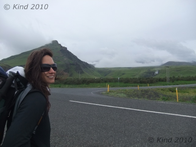
In the morning the full house erupted rather at once. Notable events of the morning: the hut keeper didn’t recognize me, and was obviously perplexed how I’d gotten into the place during the night without him noticing. The female occupant of the bunk above ours tried to climb up the wall because I was blocking the way to the ladder (the long table down the center of the hut could either be walked around or sat at, not both at the same time- the space was too tight). She was using admirable climbing form, and had her feet above her hands before the sideboard she was grasping gave way and she crashed full onto her back to the floor. I broke her fall a little, and the Belgian snatched a cup of tea out of her path preventing multiple scaldings. She leapt straight up, mostly embarrassed, but it was a hell of a crunch. She thought she’d killed my brother I think, but it was just his backpack.

Rustling around all the other hikers trying at once to stuff bags and get awkwardly out the door, we got ourselves packed and squeezed out, chatting for some minutes on the deck with an Icelander who was thrilled to be escorting two American friends over this hike. The climber girl who had fallen on me, and her boyfriend, in fact. He rhapsodized about fiskar (dried fish) with butter, and proudly shared some orange flavoured Icelandic chocolate, creating instant addicts out of us. The morning was clear and crisp, a “bracing” cold, and the mist was scuttling away so we could see where we had been the night before- an expanse of rolling hills pocked with those mysterious pits. The strange bowls were created by the action of the sun on the layer of ash heating the ice beneath, he explained, and we marvelled at this phenomenon. He pointed out the path we should take down- one of many threads of footprints spidering away from the hut. We could see the tracks of a Cat through the ash that must have brought supplies. He warned us that the first half of the walk down was numbingly boring, and at that we set out into the grey ash desert.
A couple of km down we checked out the “free hut”. It was a corrugated iron shack cabled down to bolts in the ground, with an A-frame outhouse heaped in rocks to keep it from blowing away too. The door opened on an enormous mound of garbage, behind that a filthy plywood floor. The wind was whistling piercingly through the joints, rattling the windows, and banging the door against its latch. Not inviting. We agreed, we were glad we had paid for the Útivist hut.
The Icelander had been right: for a good while the walk down hill was pretty monotonous, following the treads of the Cat, which met a road, which rolled ever onward downhill through this desert of ash. Slowly, the severe landscape changed.  Green was introduced, and on our right, a creek was making itself known in a cleft that got deeper and louder every time we paused and stepped off the road to look down into it. Soon it was a foamy, milky rapids, and later, cleaner, with swirls on the surface that betrayed the speed and depth of the water now. We crossed the river once on a footbridge, and for the rest of the way, the river stayed on our right. Near that bridge we saw our first fox tracks in the ash, and shortly after that it got green. Where there’s green, there’s sheep, so we saw lots of sheep and even more sheep evidence on our way down. The sheep all stared back at us, usually while chewing rythymicly.
Today’s hike was very, very easy. Going downhill generally is. It was a steady, gentle slope. The river beside us, the Skóga, grew larger and fell over a series of falls. Not little waterfalls, either. Considering we were descending a moderate grade, it wasn’t logical how again and again, we’d encounter a huge raging waterfall. An interpretive sign at the end of the road would tell us there were 21 falls on the route we walked this day. There were at least that many. The frequent long stairstep falls probably didn’t count. Unique, gorgeous, calendar beautiful falls, every one! It was an abund ance of beauty that seemed so excessive and extravagant that it became humorous. Derek started saying “Oh, just another foss” at each, next, extraordinary spectacle. “Oh, another foss” was something we said with a grin and shrug quite often the whole rest of our trip, as Iceland turned out to be truly thick on the ground with world class waterfalls. Sometimes we’d hear the roar a ways off; sometimes the sound would be blocked by the land, or we’d turn a corner to discover another, suddenly. Sometimes the trail would wind to the base of a foss, sometimes you would see one below you from the top of a cliff. At every one we were just killing ourselves that we had no camera at all at this point to preserve it with, and we’d just pause and stare instead, trying to fix it in memory. The sound and the mist and the “good ions” made for a very peaceful day’s walk downhill. It was quite far, but not at all hard. The nearer we drew to Skógar, the more oncoming hikers we saw, some out for a day hike up the Skóga, some setting out for Básar.
Most of the time we were walking through trenches in the grass that were sometimes hip deep. The walking trails had compacted down, digging a ditch through the sod. This turned out to be characteristic of trails everywhere in Iceland. When they got too uncomfortably deep, a new trail would start right beside it, so in softer places there would be two or three trenches of varying depths with obvious historical order.

Our hike terminated at Skógafoss, a 62m waterfall missed by few tourists, because it’s readily accessible right off the Ring road at Skógar. We came on it from above, climbing a stile, having a dizzying look down the falls, and at the backs of the gulls circling in the mist and nesting in the mossy rocks. It was like reentering another world; as a tourist attraction, Skógafoss is very well traveled. The steel stairs to the top of the foss are a revolving treadmill of steady foot traffic at all hours. We were grubby, backpacked, and all serene from solitude and exercise. Who were all these people? Society has benefits though- we beelined to the visitor’s centre to immediately plug in our camera batteries and eat, as we had budgeted very accurately for food. In other words, we had none left. Menu options? Minimal. Fries. Chocolate.
After the recharge, we went back to the waterfall and climbed it again to get some pictures. Then we got on the road and hitched out of Skógar, headed to Vík. Vík is supposed to be a must-see for exceptional basalt columns rising out of the ocean at Reynisdrangur, and the sea arch at Dyrhólaey, and I really wanted to take this in, but we never did. Ironically, we ended up passing through Vík FOUR times, but sadly it remained a list item for “next time”.

This time, it was raining, and we lucked out on a really long ride who was going straight through to Höfn, so we did not stop in Vík, but took the ride to Skaftafell. This super friendly guy who was thrilled to stop anywhere we we curious about to take a picture, and who talked endlessly about the beauty and history of his country as we drove through it, just happened to be former CEO of one of Iceland’s big three banks. Yep, all in a normal day for him to pick up a couple of unwashed Canadian backpackers in the rain. He totally resisted my attempts to draw him out on the topic of Iceland’s recent, crushing economic crash, however.

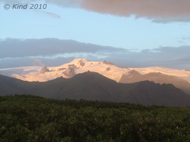
It was hard to grasp the magnitude of the event from ground level, but this drive crossed miles of sandar -devastation created by the jokülhlaup of the 1362 eruption of the volcano Öræfi. This sandar, Skeiðarársandar, is the largest in the world, a 1000 sq km floodplain of sand deposited by billions of gallons of water released from the glacier by the volcano’s heat beneath it. Even to say you could see it from space is an understatement. A smaller but more recent jokülhlaup event in 1996 took out all the bridges across it like they were made of matchsticks (see picture). When we later saw it from a height, the grey plain is so large that it fades into mist at the horizon, and is totally impossible to take a picture of. It’s just so big, it’s all that you see, for as far as you can see.

At Skaftafell we were greeted by a huge, modern, bustling visitor’s centre, gift shop, and regimented square acres of green lawn for a campsite, which we promptly set our tents up on, in the shadow of a green mound of a mountain. Our tents drew comments, based on their resemblance to alien spacecraft. I didn’t think they were that weird, but I guess, a bit different. Derek did a lot of research before buying our tents, based on weight, ease of setup, and packability. I loved mine. Derek spent an inordinate amount of time fidgeting with his, usually every night, trying to get it perfect. Both of them were ultralight, set up pretty quickly, and dried out very fast, which was perhaps the best feature, since every day we’d wake up in heavy dew if not rain.

Tired from the hike, we got showers (cold), didn’t do laundry (huge lineup), charged all our accessories (“chargers found plugged in here will be confiscated”), and ate in the cafe. The cafe served coffee, sheep soup, cake, skyr, and junk food, all shockingly expensive. I stocked up on skyr, cheese, and chips. My love affair was skyr was just beginning; Derek had already had enough. We watched the looped movie about the ’96 jokülhlaup, repeatedly. I kept falling asleep in it, waking up, and then watching it again to see the parts I’d missed, only to nod off again, until i gave up and went to bed. Well, first: I was craving a hot spring, we were hitting a week here without having been in one, and everyone we talked to was raving about hot spring this and that, so I hitched up the road to a pool noted in the LP that was supposed to be very nice, only to arrive just as they were closing for the night, alas. It was dull, rainy, and we couldn’t see a thing for the heavy fog, but we were content to crash.


